File:Extrusion in mapnik16.png
Jump to navigation
Jump to search


No higher resolution available.
Extrusion_in_mapnik16.png (450 × 516 pixels, file size: 67 KB, MIME type: image/png)
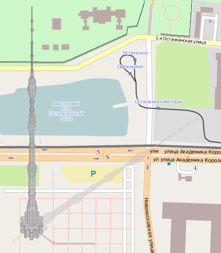
Komяpa has found a way to render 3D buildings with Mapnik. Famous Ostankino tower (drawn by Hind) looks very real! Discussion in Russian and more screenshots.
This is a Featured image, which means that it has been identified as one of the best examples of OpenStreetMap mapping, or that it provides a useful illustration of the OpenStreetMap project. If you know another image of similar quality, you can nominate it on Featured image proposals.
Front-page image for week 51 of 2010 (20–26 Dec.).
- Image descriptions
- Deutsch : Komяpa fand eine Möglichkeit, 3D-Gebäude zu rendern. Der Ostankino-Turm (angelegt von Hind) sieht realitätsnah aus! Forumsdiskussion (automatisch übersetzt).
- English : Komяpa has found a way to render 3D buildings. Famous Ostankino tower (drawn by Hind) looks very real! Some more.
- français : Komяpa a trouvé une façon de faire le rendu de bâtiments 3D avec Mapnik. La célèbre tour "Ostankino" (dessinée par Hind) a l'air très réaliste! D'autres exemples.
- italiano : Komяpa ha trovato il modo di visualizzare in 3D gli edifici con Mapnik. La famosa torre di Ostankino (disegnata da Hind) sembra molto realistica! Altri edifici.
- lietuvių : Komяpa rado būdą, kaip atvaizduoti 3D-pastatus programos Mapnik pagalba. Ostankino televizijos bokštas (nupiešė Hind) atrodo nuostabiai! Diskusija.
- polski : Komяpa znalazł sposób na renderowanie trójwymiarowych budynków. Sławna wieża Ostankino (wyrysowana przez Hinda) prezentuje się bardzo naturalnie! Więcej (Pałac kultury i Nauki).
- русский : Komяpa умеет рендерить 3D-здания с помощью Mapnik. Останкинская башня (нарисована Hind) выглядит чудесно! Обсуждение.
- 中文(繁體) : Komяpa開發以Mapnik繪製3D建築物的方法。知名的奧斯坦金諾電視塔 (Ostankino tower) (Hind畫的)就表現得相當逼真!更多實例。
Licensing
![]()
Contains map data © OpenStreetMap contributors, made available under the terms of the Creative Commons Attribution-ShareAlike 2.0 (CC-BY-SA-2.0).
File history
Click on a date/time to view the file as it appeared at that time.
| Date/Time | Thumbnail | Dimensions | User | Comment | |
|---|---|---|---|---|---|
| current | 10:47, 20 December 2010 | | 450 × 516 (67 KB) | Zverik (talk | contribs) |
You cannot overwrite this file.