File:FHRS Postcode OSM Highway.jpeg
Jump to navigation
Jump to search


Size of this preview: 800 × 600 pixels. Other resolutions: 320 × 240 pixels | 640 × 480 pixels | 1,024 × 768 pixels | 1,280 × 960 pixels | 2,362 × 1,771 pixels.
Original file (2,362 × 1,771 pixels, file size: 661 KB, MIME type: image/jpeg)
Summary
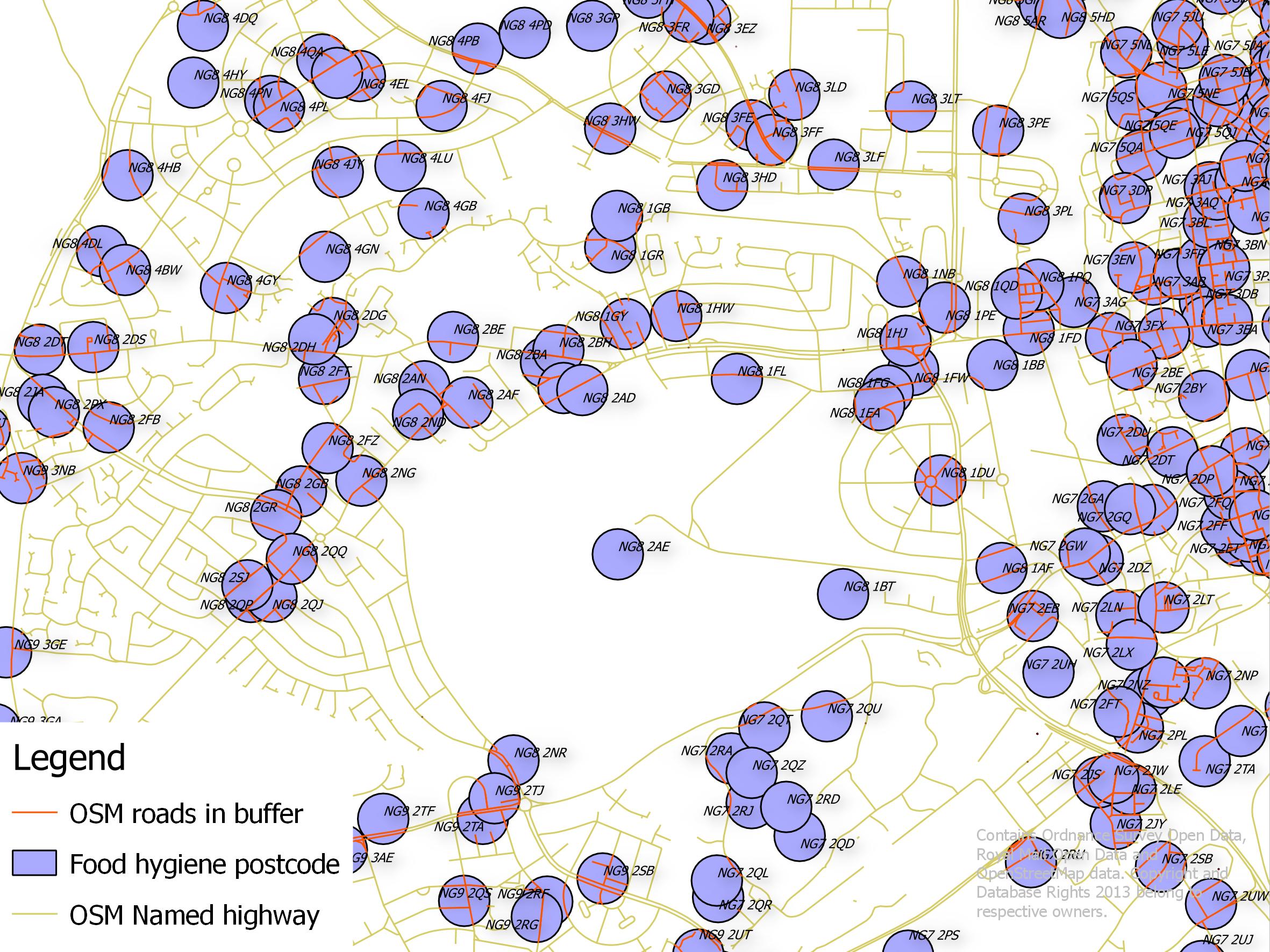
Linking Food Hygiene Open Data to OSM highways.
Food Hygiene Open Data is a potentially rich set of address and other data for OSM. Records are located to postcode centroid but contain full addresses. This image shows an intermediate step in assigning the postcodes to an individual named road. Work done at OSM London Hack Weekend November 2013.
This is a Featured image, which means that it has been identified as one of the best examples of OpenStreetMap mapping, or that it provides a useful illustration of the OpenStreetMap project. If you know another image of similar quality, you can nominate it on Featured image proposals.
Front-page image for week 49 of 2013 (2–8 Dec.).
- Image descriptions
- Deutsch : Kombination von UK Food Hygiene Rating System-Daten (lizenziert unter der Open Government License) und OSM-Straßen. Dies ist ein potenziell wertvoller (Adress-)Datensatz für OSM. Die Eintragungen befinden sich am PLZ-Schwerpunkt, enthalten aber komplette Adressen. Dieses Bild zeigt einen Zwischenschritt bei der Zuordnung der Postleitzahlen zu den einzelnen Straßennamen. Das Werk wurde beim London Hack Weekend am letzten Wochenende erstellt.
- English : Linking UK Food Hygiene Rating System data (licensed under the Open Government License) to OSM highways. This is a potentially rich set of address and other data for OSM. Records are located to postcode centroid but contain full addresses. This image shows an intermediate step in assigning the postcodes to an individual named road. Work done at London Hack Weekend last weekend.
- español : Combinación de datos UK Food Hygiene Rating System (bajo la licencia de Open Government License) y carreteras-OSM. Se trata de un potencial conjunto de direcciones y otros datos para OSM. Los registros están localizados en el centroide del código postal pero contienen la dirección completa. Esta imagen muestra un paso intermedio en la asignación de códigos postales a los nombres de las calles individuales. El trabajo estuvo a cargo del London Hack Weekend el fin de semana pasado.
- italiano : Collegamento tra i dati dello UK Food Hygiene Rating System (distribuiti sotto la Open Government License) e le highway in OSM. Questo è un insieme potenzialmente ricco di indirizzi e altri dati per OSM. I record sono posizionati sul centroide del codice postale ma contengono indirizzi completi. Questa immagine mostra un passo intermedio dell'assegnazione dei codici postali a una strada con un nome specificato. Lavoro fatto al London Hack Weekend lo scorso fine settimana.
- русский : Объединение дорожной сети ОСМ и данных Британской системы рейтинга гигиены питания, которые распространяются под свободной лицензией. У такого симбиоза есть немалый потенциал: записи привязаны к центройдам почтовых индексов и содержат адресную информацию. На изображении показан процесс привязки почтовых индексов к улицам, эта работа была сделана на лондонском хак-уикенде в ноябре 2013 года.
- 中文(简体) : 连结英国食品卫生评分系统资料(采用Open GOvernment License 授权)到开放街图公路。这组资料拥有数量多的地址资料,丰富开放街图上的资料。记录资料有邮递区号的中心点,也有完整的地址资料。这张图显示将邮递区号与各个不同名字的道路连结的过程。整个连结的工作是在上周London Hack Weekend 完成。
- 中文(繁體) : 連結英國食品衛生評分系統資料(採用 Open GOvernment License 授權)到開放街圖公路。這組資料擁有數量多的地址資料,豐富開放街圖上的資料。記錄資料有郵遞區號的中心點,也有完整的地址資料。這張圖顯示將郵遞區號與各個不同名字的道路連結的過程。整個連結的工作是在上週 London Hack Weekend 完成。
Licensing
![]()
![]()
![]()
This work is licensed under the Creative Commons Attribution-ShareAlike 2.0 License.
Attribution not specified as a parameter! THIS LICENSE ALWAYS REQUIRES ATTRIBUTION! Use {{CC-BY-SA-2.0|Attribution, typically name of author}} See Template:CC-BY-SA-2.0 for full description how this template should be used.
Note, there is
There is also
Attribution not specified as a parameter! THIS LICENSE ALWAYS REQUIRES ATTRIBUTION! Use {{CC-BY-SA-2.0|Attribution, typically name of author}} See Template:CC-BY-SA-2.0 for full description how this template should be used.
Note, there is
{{CC-BY-SA-2.0 OpenStreetMap}} for files based on old OSM map data, before the license change made on 2012-09-12.There is also
{{OSM Carto screenshot||old_license}} for files based on old OSM map data, before the license change made on 2012-09-12, created using OSM Carto map style.
File history
Click on a date/time to view the file as it appeared at that time.
| Date/Time | Thumbnail | Dimensions | User | Comment | |
|---|---|---|---|---|---|
| current | 19:20, 2 December 2013 | | 2,362 × 1,771 (661 KB) | SK53 (talk | contribs) | Linking Food Hygiene Open Data to OSM highways. Food Hygiene Open Data is a potentially rich set of address and other data for OSM. Records are located to postcode centroid but contain full addresses. This image shows an intermediate step in assigning... |
You cannot overwrite this file.