File:FIväistääJepjosvaloton.png
Jump to navigation
Jump to search

No higher resolution available.
FIväistääJepjosvaloton.png (366 × 340 pixels, file size: 121 KB, MIME type: image/png)
Summary
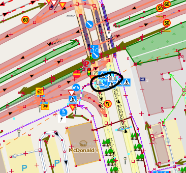
A intersection in Finland between a cycleway and a road. Normally controlled by traffic signals, but if they are not in effect, cyclists must always give way to the drivers on the tertiary road in the crossing marked with a circle.
(OSM data in JOSM with OSM "standard" layer tiles in the background)
Licensing
![]()
![]()
![]()
This work is licensed under the Creative Commons Attribution-ShareAlike 2.0 License.
Attribution not specified as a parameter! THIS LICENSE ALWAYS REQUIRES ATTRIBUTION! Use {{CC-BY-SA-2.0|Attribution, typically name of author}} See Template:CC-BY-SA-2.0 for full description how this template should be used.
Note, there is
There is also
Attribution not specified as a parameter! THIS LICENSE ALWAYS REQUIRES ATTRIBUTION! Use {{CC-BY-SA-2.0|Attribution, typically name of author}} See Template:CC-BY-SA-2.0 for full description how this template should be used.
Note, there is
{{CC-BY-SA-2.0 OpenStreetMap}} for files based on old OSM map data, before the license change made on 2012-09-12.There is also
{{OSM Carto screenshot||old_license}} for files based on old OSM map data, before the license change made on 2012-09-12, created using OSM Carto map style.
File history
Click on a date/time to view the file as it appeared at that time.
| Date/Time | Thumbnail | Dimensions | User | Comment | |
|---|---|---|---|---|---|
| current | 16:29, 22 August 2013 | | 366 × 340 (121 KB) | Alv (talk | contribs) | A intersection in Finland between a cycleway and a road. Normally controlled by traffic signals, but if they are not in effect, cyclists must always give way to the drivers on the tertiary road in the crossing marked with a circle. (OSM data in JOSM ... |
You cannot overwrite this file.
File usage
The following page uses this file: