File:Gandaria, Dhaka, Bangladesh dense mapping.png
Jump to navigation
Jump to search


No higher resolution available.
Gandaria,_Dhaka,_Bangladesh_dense_mapping.png (574 × 394 pixels, file size: 243 KB, MIME type: image/png)
Summary
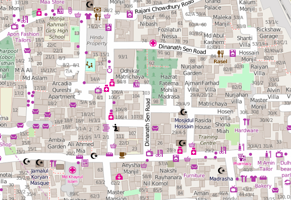
The Bangladesh OpenStreetMap community (facebook group) together with the Red Cross have been mapping the dense district Gandaria in Dhaka
"standard" OSM style view of here on the map: http://www.openstreetmap.org/#map=17/23.70261/90.42441
This is a Featured image, which means that it has been identified as one of the best examples of OpenStreetMap mapping, or that it provides a useful illustration of the OpenStreetMap project. If you know another image of similar quality, you can nominate it on Featured image proposals.
Front-page image for week 43 of 2015 (19–25 Oct.).
- Image descriptions
- Bahasa Indonesia : Masyarakat Bangladesh OpenStreetMap (facebook group) bersama-sama dengan Palang Merah telah memetakan kawasan padat Gandaria di Dhaka
- Bahasa Melayu : Komuniti OpenStreetMap Bangladesh (kumpulan Facebook) dengan Palang Merah berkerjasama memetakan kawasan Gandaria di Dhaka yang padat.
- English : The Bangladesh OpenStreetMap community (facebook group) together with the Red Cross have been mapping the dense district of Gandaria in Dhaka
- italiano : La comunità di OpenStreetMap in Bangladesh (gruppo su Facebook) insieme alla Red Cross ha mappato il denso distretto di Gandaria a Dhaka.
- русский : Этот густонаселённый район Дакки (столицы Бангладеша) нанесли на карту участники местного сообщества ОСМ при поддержке Красного креста.
- 中文(简体) : 孟加拉开放街图社群(脸书社团)一起与红十字会合作绘制达卡人口聚集区Gandaria一带状况。
- 中文(繁體) : 孟加拉開放街圖社群(臉書社團)一起與紅十字會合作繪製達卡人口聚集區Gandaria一帶狀況。
Licensing
| Contains map data © OpenStreetMap contributors, made available under the terms of the Open Database License (ODbL).
The ODbL does not require any particular license for maps produced from ODbL data, produced maps may be subject also to other licences. |
File history
Click on a date/time to view the file as it appeared at that time.
| Date/Time | Thumbnail | Dimensions | User | Comment | |
|---|---|---|---|---|---|
| current | 13:31, 19 October 2015 | | 574 × 394 (243 KB) | Harry Wood (talk | contribs) | Map of the dense district of Gandaria in Dhaka, Bangladesh http://www.openstreetmap.org/#map=17/23.70261/90.42441 |
You cannot overwrite this file.
File usage
The following 9 pages use this file: