File:Garmin-frikart-mtbmap.png
Jump to navigation
Jump to search

No higher resolution available.
Garmin-frikart-mtbmap.png (160 × 240 pixels, file size: 11 KB, MIME type: image/png)
Summary
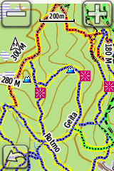
Skjermbilde av MTB stioverlay-kart på Garmin-GPS
Licensing
![]()
![]()
![]()
This work is licensed under the Creative Commons Attribution-ShareAlike 3.0 License.
Attribution not specified as a parameter! THIS LICENSE ALWAYS REQUIRES ATTRIBUTION! Use {{CC-BY-SA-3.0|Attribution, typically name of author}} See Template:CC-BY-SA-3.0 for full description how this template should be used.
Attribution not specified as a parameter! THIS LICENSE ALWAYS REQUIRES ATTRIBUTION! Use {{CC-BY-SA-3.0|Attribution, typically name of author}} See Template:CC-BY-SA-3.0 for full description how this template should be used.
File history
Click on a date/time to view the file as it appeared at that time.
| Date/Time | Thumbnail | Dimensions | User | Comment | |
|---|---|---|---|---|---|
| current | 10:48, 28 October 2015 | | 160 × 240 (11 KB) | Anderfo (talk | contribs) | Better location for a screenshot |
| 18:57, 11 June 2014 |  | 160 × 240 (36 KB) | Anderfo (talk | contribs) | Skjermbilde av MTB stioverlay-kart på Garmin-GPS |
You cannot overwrite this file.
File usage
The following 2 pages use this file:
- No:Mountain biking
- File:Stioverlay-screenshot.png (file redirect)