File:Geobretagne-osm-road-ratio.jpg
Jump to navigation
Jump to search


Size of this preview: 800 × 466 pixels. Other resolutions: 320 × 186 pixels | 640 × 373 pixels | 1,024 × 596 pixels | 1,280 × 745 pixels | 1,918 × 1,117 pixels.
Original file (1,918 × 1,117 pixels, file size: 763 KB, MIME type: image/jpeg)
Summary
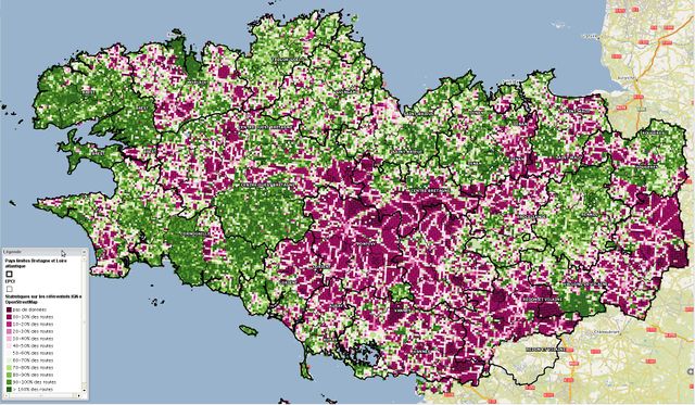
ratio osm road length / national operator IGN road length on a ~ 1km x 1km grid (same as osmqa) over Brittany, FR. Dark green means over 100%, green means over 50%, purple means under 50%. Source : BT Topo (C) IGN 2010, OpenStreetMap datas.
Licensing
![]()
![]()
![]()
This work is licensed under the Creative Commons Attribution-ShareAlike 2.0 License.
Attribution not specified as a parameter! THIS LICENSE ALWAYS REQUIRES ATTRIBUTION! Use {{CC-BY-SA-2.0|Attribution, typically name of author}} See Template:CC-BY-SA-2.0 for full description how this template should be used.
Note, there is
There is also
Attribution not specified as a parameter! THIS LICENSE ALWAYS REQUIRES ATTRIBUTION! Use {{CC-BY-SA-2.0|Attribution, typically name of author}} See Template:CC-BY-SA-2.0 for full description how this template should be used.
Note, there is
{{CC-BY-SA-2.0 OpenStreetMap}} for files based on old OSM map data, before the license change made on 2012-09-12.There is also
{{OSM Carto screenshot||old_license}} for files based on old OSM map data, before the license change made on 2012-09-12, created using OSM Carto map style.
This is a Featured image, which means that it has been identified as one of the best examples of OpenStreetMap mapping, or that it provides a useful illustration of the OpenStreetMap project. If you know another image of similar quality, you can nominate it on Featured image proposals.
Front-page image for week 24 of 2011 (13–19 Jun.).
- Image descriptions
- Deutsch : Vergleich der OSM-Daten der Bretagne mit den BD Topo Karten von IGN: Grüne Bereiche bedeuten, dass mehr als die Hälfte der Straßen in OSM vorhanden sind.
- English : Comparison against IGN's BD Topo maps of Brittany: Green areas mean OSM has more than half the roads mapped.
- français : Comparaison de la carte de Bretagne avec la BD Topo d'IGN : Les zones vertes signifient qu'OSM a plus de la moitié des routes de cartographiées.
- italiano : Confronto con le mappe topografiche IGN BD Topo della Bretagna: le aree verdi evidenziano le zone in cui OSM possiede più della metà delle strade.
- русский : Сравнение с картами Бретани IGN BD Topo: Зеленым закрашены области, где в OSM содержится более половины имеющихся дорог.
- 中文(简体) : IGNBD Topo英国地图的比对:绿色的区域表示在OSM上有半数的道路已经绘制了。
- 中文(繁體) : IGNBD Topo英國地圖的比對:綠色的區域表示在OSM上有半數的道路已經繪製了。
File history
Click on a date/time to view the file as it appeared at that time.
| Date/Time | Thumbnail | Dimensions | User | Comment | |
|---|---|---|---|---|---|
| current | 17:21, 6 May 2011 | | 1,918 × 1,117 (763 KB) | FPH (talk | contribs) | ratio osm road length / national operator IGN road length on a ~ 1km x 1km grid (same as osmqa) over Britanny, FR. Dark green means over 100%, green means over 50%, purple means under 50%. Source : BT Topo (C) IGN 2010, OpenStreetMap datas. |
You cannot overwrite this file.
File usage
The following 12 pages use this file:
- Carte d'avancement OpenStreetMap en Bretagne
- Community Updates/2011-06-13
- Featured images/Apr-Jun 2011
- List of featured images/2011
- Template:DE:Featured image p2
- Template:FR:Featured image p2
- Template:Featured image p2
- Template:Iotw image/2011-24
- DE:Featured images/Apr-Jun 2011
- FR:Featured images/Apr-Jun 2011
- FR:ProjetLyceesBretagne
- IT:Featured images/Apr-Jun 2011