File:Georgia International E Roads.svg
Jump to navigation
Jump to search


Size of this PNG preview of this SVG file: 800 × 426 pixels. Other resolutions: 320 × 170 pixels | 640 × 341 pixels | 1,024 × 545 pixels | 1,280 × 681 pixels | 1,715 × 913 pixels.
Original file (SVG file, nominally 1,715 × 913 pixels, file size: 394 KB)
This file and its description are from Wikimedia Commons.
Summary
| Description |
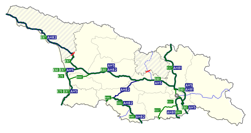
English: Overview of all European E-routes in Georgia |
| Date | |
| Source | Own work |
| Author | Labrang |
Licensing
I, the copyright holder of this work, hereby publish it under the following license:
This file is licensed under the Creative Commons Attribution-Share Alike 4.0 International license.
- You are free:
- to share – to copy, distribute and transmit the work
- to remix – to adapt the work
- Under the following conditions:
- attribution – You must give appropriate credit, provide a link to the license, and indicate if changes were made. You may do so in any reasonable manner, but not in any way that suggests the licensor endorses you or your use.
- share alike – If you remix, transform, or build upon the material, you must distribute your contributions under the same or compatible license as the original.
File history
Click on a date/time to view the file as it appeared at that time.
| Date/Time | Thumbnail | Dimensions | User | Comment | |
|---|---|---|---|---|---|
| current | 16:55, 20 July 2021 | | 1,715 × 913 (394 KB) | wikimediacommons>Labrang | improved color coding Asian Highway segments |
File usage
The following page uses this file: