File:Geoshepherds cross-country ski mapping.png
Jump to navigation
Jump to search


No higher resolution available.
Geoshepherds_cross-country_ski_mapping.png (558 × 417 pixels, file size: 350 KB, MIME type: image/png)
Summary
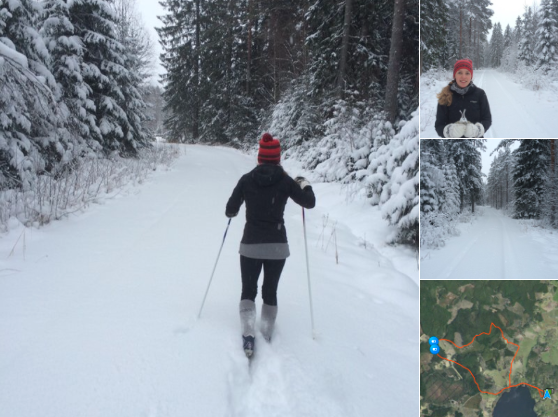
GeoShepherds tweeted this image of them cross-country ski mapping
Photographer unknown, but permission to use. Safe to say "CC-BY-SA GeoShepherds"
This is a Featured image, which means that it has been identified as one of the best examples of OpenStreetMap mapping, or that it provides a useful illustration of the OpenStreetMap project. If you know another image of similar quality, you can nominate it on Featured image proposals.
Front-page image for week 4 of 2016 (25–31 Jan.).
- Image descriptions
- asturianu : «¡Nun dexaremos que la nieve nos detenga!» La xente de la empresa de diseñu sueca geoshepherds salieron a facer mapes colos esquís de fondo!
- English : “We won‘t let the snow stop us!” The folks at swedish design firm geoshepherds, have been out mapping on their cross-country skis!
- italiano : «La neve non ci fermerà!» I tizi della società svedese di design geoshepherds sono andati a mappare con gli sci da fondo!
- русский : «Снег нас не остановит!» Работники из шведской дизайнерской фирмы Геошепердс устроили лыжную покатушку, чтобы улучшить карту.
- 中文(简体) : 「我们不会让大雪阻止我们的!」瑞典设计公司geoshepherds 的人,用滑雪的方式跨越整个国家出外画地图!
- 中文(繁體) : 「我們不會讓大雪阻止我們的!」瑞典設計公司 geoshepherds 的人,用滑雪的方式跨越整個國家出外畫地圖!
Licensing
![]()
![]()
![]()
This work is licensed under the Creative Commons Attribution-ShareAlike 2.0 License.
Attribution not specified as a parameter! THIS LICENSE ALWAYS REQUIRES ATTRIBUTION! Use {{CC-BY-SA-2.0|Attribution, typically name of author}} See Template:CC-BY-SA-2.0 for full description how this template should be used.
Note, there is
There is also
Attribution not specified as a parameter! THIS LICENSE ALWAYS REQUIRES ATTRIBUTION! Use {{CC-BY-SA-2.0|Attribution, typically name of author}} See Template:CC-BY-SA-2.0 for full description how this template should be used.
Note, there is
{{CC-BY-SA-2.0 OpenStreetMap}} for files based on old OSM map data, before the license change made on 2012-09-12.There is also
{{OSM Carto screenshot||old_license}} for files based on old OSM map data, before the license change made on 2012-09-12, created using OSM Carto map style.
File history
Click on a date/time to view the file as it appeared at that time.
| Date/Time | Thumbnail | Dimensions | User | Comment | |
|---|---|---|---|---|---|
| current | 15:14, 14 January 2016 | | 558 × 417 (350 KB) | Harry Wood (talk | contribs) | GeoShepherds [https://twitter.com/geoshepherds/status/687276820220276736 tweeted this image] of them cross-country ski mapping Photographer unknown, but [https://twitter.com/geoshepherds/status/687650852987887616 permission to use]. Safe to say "CC-BY... |
You cannot overwrite this file.
File usage
The following 9 pages use this file: