File:Glasgow park access network.png
Jump to navigation
Jump to search


Size of this preview: 800 × 471 pixels. Other resolutions: 320 × 188 pixels | 640 × 377 pixels | 1,073 × 632 pixels.
Original file (1,073 × 632 pixels, file size: 160 KB, MIME type: image/png)
Summary
This image on flickr for more description and annotations
by Tim Foster (User:Hawkeyes / 'macroflight' on flickr )
See also File:Glasgow park access network (8520851663).png
.png)
Licensing
![]()
![]()
![]()
This work is licensed under the Creative Commons Attribution-ShareAlike 2.0 License.
Attribution not specified as a parameter! THIS LICENSE ALWAYS REQUIRES ATTRIBUTION! Use {{CC-BY-SA-2.0|Attribution, typically name of author}} See Template:CC-BY-SA-2.0 for full description how this template should be used.
Note, there is
There is also
Attribution not specified as a parameter! THIS LICENSE ALWAYS REQUIRES ATTRIBUTION! Use {{CC-BY-SA-2.0|Attribution, typically name of author}} See Template:CC-BY-SA-2.0 for full description how this template should be used.
Note, there is
{{CC-BY-SA-2.0 OpenStreetMap}} for files based on old OSM map data, before the license change made on 2012-09-12.There is also
{{OSM Carto screenshot||old_license}} for files based on old OSM map data, before the license change made on 2012-09-12, created using OSM Carto map style.
This is a Featured image, which means that it has been identified as one of the best examples of OpenStreetMap mapping, or that it provides a useful illustration of the OpenStreetMap project. If you know another image of similar quality, you can nominate it on Featured image proposals.
Front-page image for week 10 of 2013 (4–10 Mar.).
- Image descriptions
- Deutsch : Diese Karte zeigt die Entfernung von Parks in Glasgow. Dabei werden OSM Daten und GRASS/QGIS Netzwerkanalyse verwendet. Je dunkelroter, desto weiter entfernt
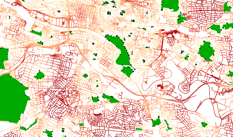
- English : Map showing distance from parks in Glasgow, using openstreetmap data and GRASS/QGIS network analysis. Dark red means further away from a park.
- français : Carte montrant la distance par rapport aux différents parcs de Glasgow utilisant les données d'OpenStreetMap et du réseau d'analyse GRASS/QGIS. Rouge sombre signifie plus éloigné d'un parc.
- italiano : Una mappa che mostra la distanza dai parchi di Glasgow usando i dati di OpenStreetMap e l'analisi delle reti di GRASS/QGIS. Il rosso più scuro indica una maggiore distanza dai parchi.
- 中文(简体) : 这张格拉斯哥公园地图使用开放街图资料,并且运用GRASS/QGIS的网路分析功能,越远离公园的地方显示的颜色是深红色。
- 中文(繁體) : 這張格拉斯哥公園地圖使用開放街圖資料,並且運用GRASS/QGIS的網路分析功能,越遠離公園的地方顯示的顏色是深紅色。
File history
Click on a date/time to view the file as it appeared at that time.
| Date/Time | Thumbnail | Dimensions | User | Comment | |
|---|---|---|---|---|---|
| current | 11:11, 3 March 2013 | | 1,073 × 632 (160 KB) | Harry Wood (talk | contribs) | [http://www.flickr.com/photos/29266908@N02/8520851663/in/photostream/ this image on flickr] for more description and annotations. flickr user 'macroflight' |
You cannot overwrite this file.
File usage
The following file is a duplicate of this file (more details):
- File:Glasgow park access network (8520851663).png from Wikimedia Commons
.png)
The following 7 pages use this file: