File:Global Relative Share Pie Chart.png
Jump to navigation
Jump to search


Size of this preview: 649 × 599 pixels. Other resolutions: 260 × 240 pixels | 520 × 480 pixels | 832 × 768 pixels | 1,109 × 1,024 pixels | 1,414 × 1,306 pixels.
Original file (1,414 × 1,306 pixels, file size: 87 KB, MIME type: image/png)
Annotated pie chart which compare's each country's share of waterway=riverbank tags on a global scale. Countries with less than 100 instances of the tag are not labeled.
This infographic was made by OSM user MapSpot.
Applications used:
- Overpass Turbo for OSM tag data collection
- Microsoft Excel for tag data tabulation and chart generation
- Apple Markup for chart labels
![]()
This image or logo only consists of typefaces, individual words, slogans, or simple geometric shapes. These are not eligible for copyright alone because they are not original enough, and thus the image is considered to be in the public domain.
See Public domain or Restricted materials on Wikipedia for more information.
Please note: The public domain status of this work is only in regards to its copyright status. There may be other intellectual property restrictions protecting this image, such as trademarks or design patents if it is a logo.
See
Please note: The public domain status of this work is only in regards to its copyright status. There may be other intellectual property restrictions protecting this image, such as trademarks or design patents if it is a logo.
File history
Click on a date/time to view the file as it appeared at that time.
| Date/Time | Thumbnail | Dimensions | User | Comment | |
|---|---|---|---|---|---|
| current | 21:01, 14 June 2022 | | 1,414 × 1,306 (87 KB) | MapSpot (talk | contribs) | |
| 22:16, 5 March 2022 |  | 1,390 × 1,306 (143 KB) | MapSpot (talk | contribs) | ||
| 01:07, 26 February 2022 |  | 1,382 × 1,302 (163 KB) | MapSpot (talk | contribs) | ||
| 18:30, 23 February 2022 |  | 1,384 × 1,304 (181 KB) | MapSpot (talk | contribs) | ||
| 20:59, 4 January 2022 |  | 1,410 × 1,308 (223 KB) | MapSpot (talk | contribs) | ||
| 16:42, 4 January 2022 |  | 1,412 × 1,304 (242 KB) | MapSpot (talk | contribs) | ||
| 20:54, 3 January 2022 |  | 1,370 × 1,306 (321 KB) | MapSpot (talk | contribs) | ||
| 20:02, 22 December 2021 |  | 1,414 × 1,304 (386 KB) | MapSpot (talk | contribs) | ||
| 01:17, 20 December 2021 | 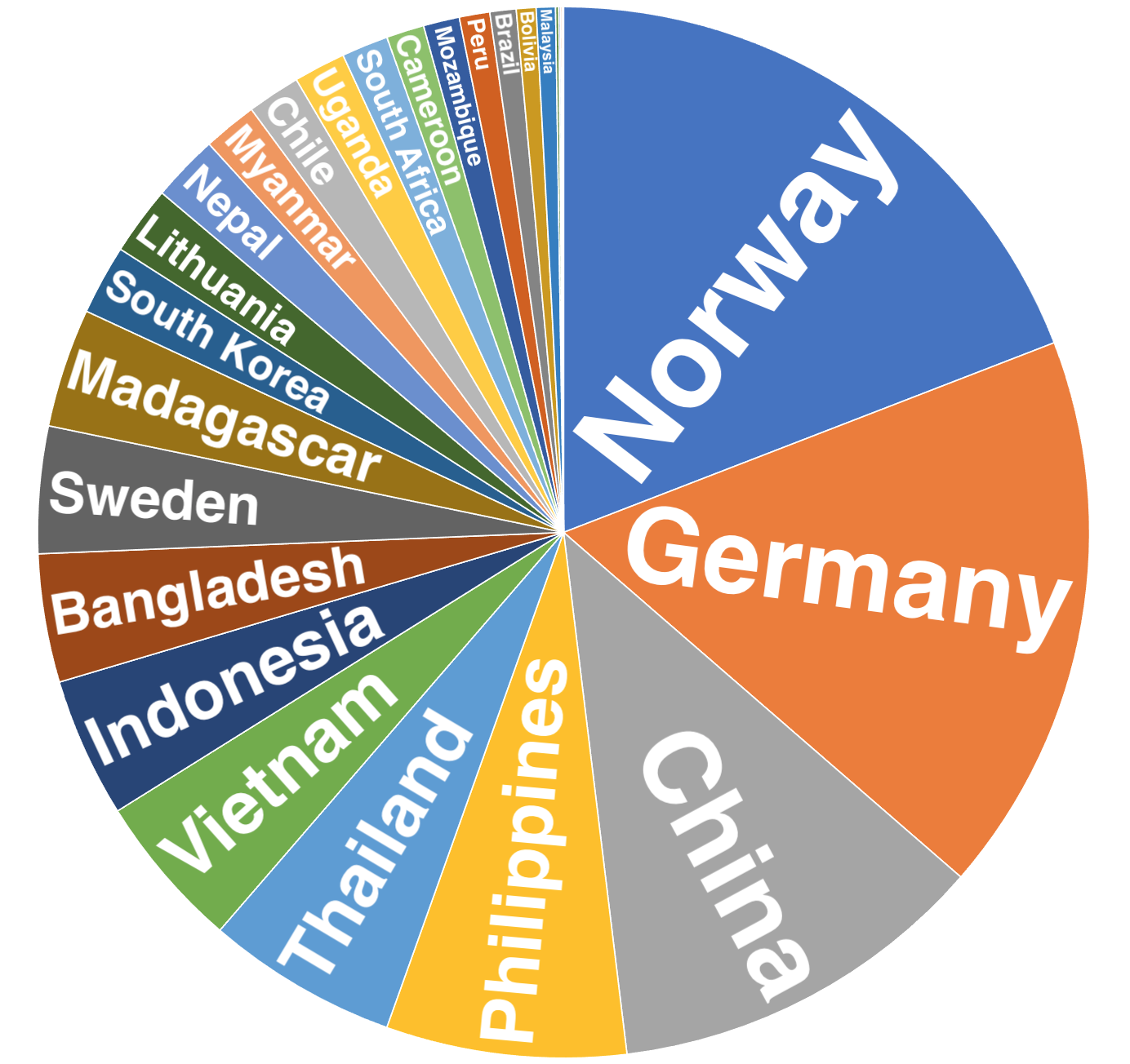 | 1,384 × 1,304 (523 KB) | MapSpot (talk | contribs) | ||
| 21:25, 4 December 2021 |  | 1,416 × 1,310 (585 KB) | MapSpot (talk | contribs) |
You cannot overwrite this file.
File usage
The following page uses this file: