File:Greenhouses westland.jpg
Jump to navigation
Jump to search


Size of this preview: 800 × 600 pixels. Other resolutions: 320 × 240 pixels | 640 × 480 pixels | 1,024 × 768 pixels | 1,280 × 960 pixels | 1,400 × 1,050 pixels.
Original file (1,400 × 1,050 pixels, file size: 277 KB, MIME type: image/jpeg)
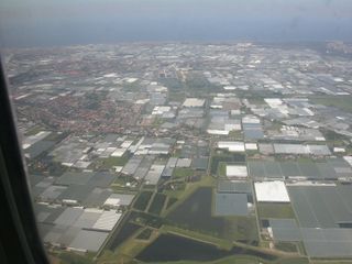
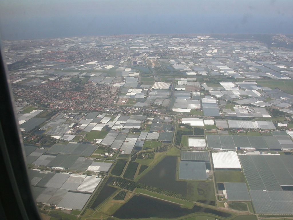
Aerial view of greenhouses in Westland, The Netherlands
![]()
This media file does not have sufficient information on its copyright status. If you have created this file yourself, or the file is available under some open licence allowing its use on OSM Wiki or the file is in the public domain, you can edit the file description page to license it under one of the allowed licences. If you did not create it and it is not in the public domain, you must ask the copyright holder for permission to release it under one of the allowed licenses. Wiki:Media file license chart may be helpful to find a suitable licence.
Files without licences marked with this template are listed in Category:Media without a license or one of its subcategories. If the file is without a known open licence: ask its uploader to clarify situation or find a replacement and mark this file with {{Superseded by Commons}} and replace its uses.
Files without licences marked with this template are listed in Category:Media without a license or one of its subcategories. If the file is without a known open licence: ask its uploader to clarify situation or find a replacement and mark this file with {{Superseded by Commons}} and replace its uses.
If uploader was notified this month: use {{No licence|subcategory=uploader notified 2024, April}} - to put media into Category:Media without a license - uploader notified 2024, April and mark image as one where uploader was notified.
File history
Click on a date/time to view the file as it appeared at that time.
| Date/Time | Thumbnail | Dimensions | User | Comment | |
|---|---|---|---|---|---|
| current | 19:15, 21 July 2009 | | 1,400 × 1,050 (277 KB) | Polderrunner (talk | contribs) | Aerial view of greenhouses in Westland, The Netherlands |
You cannot overwrite this file.
File usage
The following 95 pages use this file:
- Ar:Map Features
- Ast:Map Features
- Az:Map Features
- Bg:Map Features
- Bs:Map Features
- Cs:Key:landuse
- Cs:Map Features
- Cs:Tag:landuse=greenhouse horticulture
- Da:Map Features
- El:Map Features
- Eo:Map Features
- Fa:Map Features
- Fi:Kartan ominaisuudet
- He:Map Features
- Hr:Map Features
- Hu:Key:landuse
- Hu:Map Features
- Id:Map Features
- Key:landuse
- Ko:Key:landuse
- Ko:Tag:landuse=greenhouse horticulture
- Ko:지도 지물
- Lt:Map Features
- Lv:Land use
- Lv:Map Features
- Map features
- Ne:Map Features
- Pl:Key:landuse
- Pl:Tag:landuse=greenhouse horticulture
- Projet Garrigue
- Pt:Key:landuse
- Pt:Map Features
- Pt:Tag:landuse=greenhouse horticulture
- Ro-md:Map Features
- Ro:Map Features
- Sr:Map Features
- Sv:Map Features
- Tag:landuse=greenhouse horticulture
- Tag:raba:id=1190
- Uk:Key:landuse
- Uk:Tag:landuse=greenhouse horticulture
- Uk:Об'єкти мапи
- Zh-hans:Key:landuse
- Zh-hans:Map Features
- Zh-hans:Tag:landuse=greenhouse horticulture
- Zh-hant:Map Features
- User:Chillly/Simple Map Features
- User:H4ck3rm1k3/OSMKeys
- Wiki:Files used by data items/2
- Template:Ar:Map Features:landuse
- Template:Az:Map Features:landuse
- Template:Bs:Map Features:landuse
- Template:Ca:Map Features:landuse
- Template:Cs:Map Features:landuse
- Template:DE:Map Features:landuse
- Template:Da:Map Features:landuse
- Template:El:Map Features:landuse
- Template:Eo:Map Features:landuse
- Template:Et:Map Features:landuse
- Template:FR:Map Features:landuse
- Template:Fi:Map Features:landuse
- Template:Generic:ES:Map Features:landuse
- Template:Hr:Map Features:landuse
- Template:Hu:Map Features:landuse
- Template:IT:Map Features:landuse
- Template:Id:Map Features:landuse
- Template:JA:Map Features:landuse
- Template:Ko:Map Features:landuse
- Template:Map Features:landuse
- Template:Map Features:landuse/doc
- Template:NL:Map Features:landuse
- Template:Pl:Map Features:landuse
- Template:Pt:Map Features:landuse
- Template:RU:Map Features:landuse
- Template:Uk:Map Features:landuse
- Template:Zh-hans:Map Features:landuse
- Template:Zh-hant:Map Features:landuse
- DE:Key:landuse
- DE:Map Features
- DE:Tag:landuse=greenhouse horticulture
- FR:Key:landuse
- FR:Tag:landuse=greenhouse horticulture
- FR:Éléments cartographiques
- ES:Tag:landuse=greenhouse horticulture
- IT:Key:landuse
- IT:Map Features
- IT:Tag:landuse=greenhouse horticulture
- NL:Kaartelementen
- NL:Key:landuse
- RU:Key:landuse
- RU:Tag:landuse=greenhouse horticulture
- JA:Key:landuse
- JA:Map Features
- JA:Tag:landuse=greenhouse horticulture
- Proposal:Greenhouse horticulture