File:Hinweisschild Container voll mit OSM-Karte in Werdohl.jpg
Jump to navigation
Jump to search


Size of this preview: 400 × 600 pixels. Other resolutions: 160 × 240 pixels | 320 × 480 pixels | 512 × 768 pixels | 682 × 1,024 pixels | 1,365 × 2,048 pixels | 2,848 × 4,272 pixels.
Original file (2,848 × 4,272 pixels, file size: 4.69 MB, MIME type: image/jpeg)
This file and its description are from Wikimedia Commons.
This is a Featured image, which means that it has been identified as one of the best examples of OpenStreetMap mapping, or that it provides a useful illustration of the OpenStreetMap project. If you know another image of similar quality, you can nominate it on Featured image proposals.
Front-page image for week 21 of 2015 (18–24 May).
- Image descriptions
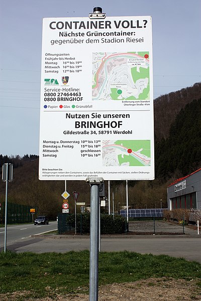
- Deutsch : Ein Hinweisschild mit Karten von OpenStreetMap zeigt die Positionen der Müllcontainer in Werdohl (Deutschland) an.
- English : A signpost designed with maps from OpenStreetMap, showing the location of recycling bins in Werdohl, Germany
- italiano : Un cartello stradale progettato com mappe di OpenStreetMap, che mostra la posizione dei contenitori per il riciclaggio in Werdohl, Germania.
- русский : Этот знак в немецком городе Вердоль показывает, где находятся ближайшие пункты приёма вторсырья. В основе карт — ОпенСтритМап.
- 中文(简体) : 使用开放街图地图的路牌,显示德国韦尔多尔一带的资源回收箱位置。
- 中文(繁體) : 使用開放街圖地圖的路牌,顯示德國韋爾多爾一帶的資源回收箱位置。
Summary
| Description |
Deutsch: Die Stadt Werdohl und der Zweckverband für Abfallwirtschaft informieren in Werdohl mit einem Hinweisschild über die Möglichkeiten Müll auch an anderen Anlaufstellen im Ort entsorgen zu können. Die Orte werden auf einer Karte gezeigt, welche von OpenStreetMap stammt. OpenStreetMap ist ein freies Projekt, das für jeden frei nutzbare Geodaten nach dem Wikiprinzip sammelt (Open Data). Mit Hilfe dieser Daten können Weltkarten errechnet oder Spezialkarten abgeleitet werden. |
| Date | |
| Source | Own work |
| Author | René Kirchhoff |
| Camera location | | View this and other nearby images on: OpenStreetMap |
|---|
Licensing
|
The photographical reproduction of this work is covered under the article § 59 of the German copyright law, which states that "It shall be permissible to reproduce, by painting, drawing, photography or cinematography, works which are permanently located on public ways, streets or places and to distribute and publicly communicate such copies. For works of architecture, this provision shall be applicable only to the external appearance."
As with all other “limits of copyright by legally permitted uses”, no changes to the actual work are permitted under § 62 of the German copyright law (UrhG). See Commons:Copyright rules by territory/Germany#Freedom of panorama for more information.
|
I, the copyright holder of this work, hereby publish it under the following license:
This file is licensed under the Creative Commons Attribution-Share Alike 4.0 International license.
- You are free:
- to share – to copy, distribute and transmit the work
- to remix – to adapt the work
- Under the following conditions:
- attribution – You must give appropriate credit, provide a link to the license, and indicate if changes were made. You may do so in any reasonable manner, but not in any way that suggests the licensor endorses you or your use.
- share alike – If you remix, transform, or build upon the material, you must distribute your contributions under the same or compatible license as the original.
I have published this image as author under the Creative-Commons-Licence CC BY-SA 4.0.. This means that free usage outside of Wikimedia projects under the following terms of licence is possible:
- The image is credited with „René Kirchhoff / Wikimedia“
If this is not possible due to shortage of space, please contact me first. - If possible a weblink to the original image would be great: https://commons.wikimedia.org/wiki/File:Hinweisschild_Container_voll_mit_OSM-Karte_in_Werdohl.jpg
| This file has been released under a license which is incompatible with Facebook's licensing terms. It is not permitted to upload this file to Facebook. |
File history
Click on a date/time to view the file as it appeared at that time.
| Date/Time | Thumbnail | Dimensions | User | Comment | |
|---|---|---|---|---|---|
| current | 17:29, 12 May 2015 | | 2,848 × 4,272 (4.69 MB) | wikimediacommons>Reneman | User created page with UploadWizard |
File usage
The following 6 pages use this file: