File:Hlotse Community Council July Mapping Party.jpg
Jump to navigation
Jump to search


Size of this preview: 550 × 599 pixels. Other resolutions: 220 × 240 pixels | 440 × 480 pixels | 890 × 970 pixels.
Original file (890 × 970 pixels, file size: 211 KB, MIME type: image/jpeg)
Summary
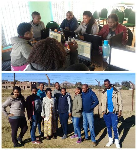
Mzwandile Thokoane from the MapLesotho project, lead a mapping event to bring advanced JOSM mapping back to Hlotse, in Leribe, Lesotho
These photos were taken by Mzwandile Thokoane along with some more he tweeted here: https://twitter.com/thokoane/status/888415608106344450
Harry mashed them into a montage for Featured images but the images are available separately in the tweet there.
This is a Featured image, which means that it has been identified as one of the best examples of OpenStreetMap mapping, or that it provides a useful illustration of the OpenStreetMap project. If you know another image of similar quality, you can nominate it on Featured image proposals.
Front-page image for week 30 of 2017 (24–30 Jul.).
- Image descriptions
- English : Mzwandile Thokoane from the MapLesotho project, lead a mapping event to bring advanced JOSM mapping back to Hlotse, in Leribe, Lesotho.
- français : Mzwandile Thokoane a organisé une cartopartie dans le cadre du projet MapLesotho afin d’apporter la cartographie avancée sous JOSM à Hlotse, chef-lieu du district de Leribe au Lesotho.
- italiano : Mzwandile Thokoane del progetto MapLesotho, ha condotto un evento di mappatura per portare la mappatura avanzata con JOSM a Hlotse, Leribe, in Lesotho.
- 中文(简体) : MapLesotho 专案的 Mzwandile Thokoane 组织绘图活动,要将进阶的 JOSM 绘图技巧带回赖索托莱里贝区的莱里贝。
- 中文(繁體) : MapLesotho 專案的 Mzwandile Thokoane 組織繪圖活動,要將進階的 JOSM 繪圖技巧帶回賴索托萊里貝區的萊里貝。
Licensing
Shared here with an open license by permission
![]()
![]()
![]()
This work is licensed under the Creative Commons Attribution-ShareAlike 2.0 License.
Attribution: Mzwandile Thokoane
Attribution: Mzwandile Thokoane
File history
Click on a date/time to view the file as it appeared at that time.
| Date/Time | Thumbnail | Dimensions | User | Comment | |
|---|---|---|---|---|---|
| current | 22:06, 23 July 2017 | | 890 × 970 (211 KB) | Harry Wood (talk | contribs) | Hlotse Community Council July Mapping Party photos by Mzwandile Thokoane https://twitter.com/thokoane/status/888415608106344450 |
You cannot overwrite this file.
File usage
The following 13 pages use this file:
- Featured images/Jul-Sep 2017
- List of featured images/2017
- Pt:Featured images/Jul-Sep 2017
- Uk:Featured images/Jul-Sep 2017
- Zh-hans:Featured images/Jul-Sep 2017
- Zh-hant:Featured images/Jul-Sep 2017
- Template:Iotw image/2017-30
- DE:Featured images/Jul-Sep 2017
- FR:Featured images/Jul-Sep 2017
- ES:Imágenes destacadas/Jul-Sep 2017
- IT:Featured images/Jul-Sep 2017
- RU:Featured images/Jul-Sep 2017
- JA:Featured images/Jul-Sep 2017