File:Hstore.jpg
Hstore.jpg (733 × 567 pixels, file size: 33 KB, MIME type: image/jpeg)
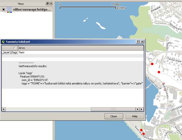
Mapserver WMS rendering basemap from the standard PostGIS tables created by osm2pgsql. On top of the basemap there is a point layer that is queried by the hstore column "keys" that is created by the new osm2pgsql option -k. Mapserver is using this query for reading the data:
DATA "way from (select (way),osm_id,tags from osm_point where ((tags->'FIXME')is not null)) as foo using unique osm_id using srid=2393"
The layer supports queries with standard WMS GetFeatureInfo query. In this example the query is sent with QGis, and server sends back all the tags of the feature.
![]()
Files without licences marked with this template are listed in Category:Media without a license or one of its subcategories. If the file is without a known open licence: ask its uploader to clarify situation or find a replacement and mark this file with {{Superseded by Commons}} and replace its uses.
If uploader was notified this month: use {{No licence|subcategory=uploader notified 2024, April}} - to put media into Category:Media without a license - uploader notified 2024, April and mark image as one where uploader was notified.
File history
Click on a date/time to view the file as it appeared at that time.
| Date/Time | Thumbnail | Dimensions | User | Comment | |
|---|---|---|---|---|---|
| current | 13:43, 18 May 2010 | | 733 × 567 (33 KB) | JRA (talk | contribs) | Mapserver WMS rendering basemap from the standard PostGIS tables created by osm2pgsql. On top of the basemap there is a point layer that is queried by the hstore column "keys" that is created by the new osm2pgsql option -k. Mapserver is using this query |
You cannot overwrite this file.
File usage
The following page uses this file: