File:Kantone der Schweiz.svg
Jump to navigation
Jump to search


Size of this PNG preview of this SVG file: 800 × 560 pixels. Other resolutions: 320 × 224 pixels | 640 × 448 pixels | 1,024 × 717 pixels | 1,280 × 896 pixels | 1,000 × 700 pixels.
Original file (SVG file, nominally 1,000 × 700 pixels, file size: 2.86 MB)
This file and its description are from Wikimedia Commons.
Summary
| Description |
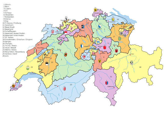
English: Vectormap of Switzerland with all canton, names and flags as separated layers
Deutsch: Vektorkarte der Schweiz mit allen Kantonen, Namen und Flaggen als separate Ebene |
| Date | |
| Source | Own work |
| Author | KarzA |
| Other versions |
[]
Derivative works of this file:
|
| SVG development |


Licensing
| I, the copyright holder of this work, release this work into the public domain. This applies worldwide. In some countries this may not be legally possible; if so: I grant anyone the right to use this work for any purpose, without any conditions, unless such conditions are required by law. |
| Annotations | This image is annotated: View the annotations at Commons |


File history
Click on a date/time to view the file as it appeared at that time.
| Date/Time | Thumbnail | Dimensions | User | Comment | |
|---|---|---|---|---|---|
| current | 19:35, 26 July 2016 | | 1,000 × 700 (2.86 MB) | wikimediacommons>Pit8404 | Kt. Zug die Fehlende Nummer 9 gesetzt, Appenzell und Waadt korrigiert, bei Graubünden die räto-romanische Bezeichnung hinzugefügt. |
File usage
The following 2 pages use this file: