File:Konsolidierung der PLZ-Relationen in Deutschland 2013 vorher nachher.png
Jump to navigation
Jump to search


Size of this preview: 800 × 347 pixels. Other resolutions: 320 × 139 pixels | 640 × 277 pixels | 1,502 × 651 pixels.
Original file (1,502 × 651 pixels, file size: 1.27 MB, MIME type: image/png)
Summary
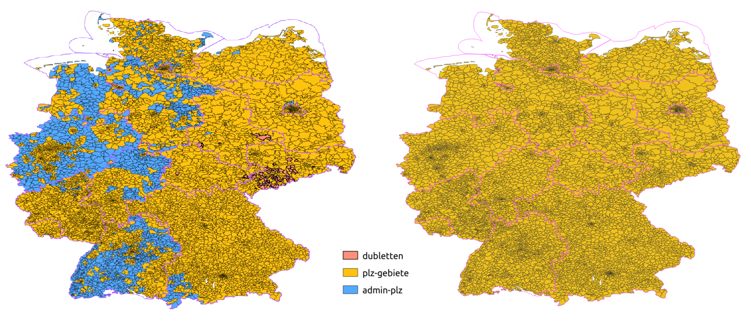
- English:
- left: Data as of 2013-12-01
- right: Data as of 2013-12-20
- colour key: duplicates, postcode areas, admin area with postal_code=*
- Deutsch:
- links: Bestand am 01.12.2013
- rechts: Bestand am 20.12.2013
- Farblegende: Dubletten, PLZ-Gebiete, administrative Grenze mit postal_code=*
- Français :
- gauche: Données au 01/12/2013
- right: Données au 20/12/2013
- code couleur: doublons, zones de code postal, zones administratives avec postal_code=*
This is a Featured image, which means that it has been identified as one of the best examples of OpenStreetMap mapping, or that it provides a useful illustration of the OpenStreetMap project. If you know another image of similar quality, you can nominate it on Featured image proposals.
Front-page image for week 2 of 2014 (6–12 Jan.).
- Image descriptions
- Deutsch : In den letzten Wochen wurden die deutschen Postleitzahlen-Gebiete konsolidiert und überprüft: Davor (linke Karte) waren viele PLZ-Gebiete nur auf administrativen Grenzrelationen getaggt, außerdem existierten Duplikate. Danach (rechte Karte) haben alle 8201 PLZ-Gebiete ihre eigene PLZ-Relation. Siehe auch die Projektseite.
- English : In the last few weeks the German postal code areas were consolidated and checked: Before (left map) some postalcodes were tagged on admin boundary relations and duplicates existed. After (right map) all 8201 postalcode areas in Germany have their own postal_code relation. See the project page (in German).
- español : En las últimas semanas las áreas del código postal alemanes fueron consolidados y controlados: Antes (mapa de la izquierda) algunos códigos postales eran puestos en la relaciones de límites administrativos y duplicando a existentes. Después (mapa de la derecha) todos los 8201 áreas de código postal en Alemania tienen su propia relación del código postal. Consulte la página del proyecto (en alemán).
- français : Ces dernières semaines les zones de code postal allemandes ont été consolidées, et vérifiées : avant (image de gauche), certains codes postaux étaient taggés sur les relations des limites administratives et il existait des doublons ; après (image de droite), l'ensemble des 8201 zones de code postal en Allemagne ont leur propre relation postal_code. Plus d'informations sur la page du projet (en allemand).
- italiano : Nelle scorse settimane le aree dei codici postali tedeschi sono state uniformate e controllate: prima (mappa a sinistra) alcuni codici postali erano assegnati alle relazioni dei confini amministrativi ed esistevano dei duplicati. Dopo (mappa a destra) tutte le 8201 aree dei codici postali in Germania hanno la propria relazione postal_code. Vedere la pagina del progetto (in tedesco).
- русский : За несколько прошедших недель в Германии были приведены в порядок все почтовые индексы. Слева показана ситуация «до»: некоторые индексы отмечены прямо на административных границах, встречаются дубликаты. Справа («после»): для каждого из 8 201 почтовых индексов создано отдельное отношение, все ошибки исправлены. Подробности — на странице проекта (на немецком).
- 中文(繁體) : 這幾週德國郵政編號與對應區域被合併與檢查核對:先前(左圖)一些郵政編號是標在行政區域關係上,因此重覆。之後(右圖)德國全部 8,201 個郵政編號區域都他獨立的郵政編號區域關係。詳情見計畫頁面(德文)。
Licensing
derived from / erstellt aus File:Plz-statistik-brd.png by / von User:Wambacher
![]()
![]()
![]()
This work is licensed under the Creative Commons Attribution-ShareAlike 2.0 License.
Attribution not specified as a parameter! THIS LICENSE ALWAYS REQUIRES ATTRIBUTION! Use {{CC-BY-SA-2.0|Attribution, typically name of author}} See Template:CC-BY-SA-2.0 for full description how this template should be used.
Note, there is
There is also
Attribution not specified as a parameter! THIS LICENSE ALWAYS REQUIRES ATTRIBUTION! Use {{CC-BY-SA-2.0|Attribution, typically name of author}} See Template:CC-BY-SA-2.0 for full description how this template should be used.
Note, there is
{{CC-BY-SA-2.0 OpenStreetMap}} for files based on old OSM map data, before the license change made on 2012-09-12.There is also
{{OSM Carto screenshot||old_license}} for files based on old OSM map data, before the license change made on 2012-09-12, created using OSM Carto map style.
Map data: © OpenStreetMap contributors
File history
Click on a date/time to view the file as it appeared at that time.
| Date/Time | Thumbnail | Dimensions | User | Comment | |
|---|---|---|---|---|---|
| current | 11:49, 30 December 2013 | | 1,502 × 651 (1.27 MB) | LordOfMaps (talk | contribs) | erstellt aus File:Plz-statistik-brd.png von User Wambacher |
You cannot overwrite this file.
File usage
The following 8 pages use this file: