File:La Vallee du Sornin.jpg
Jump to navigation
Jump to search


Size of this preview: 218 × 599 pixels. Other resolutions: 87 × 240 pixels | 174 × 480 pixels | 279 × 768 pixels | 372 × 1,024 pixels | 2,363 × 6,497 pixels.
Original file (2,363 × 6,497 pixels, file size: 2.91 MB, MIME type: image/jpeg)
Summary
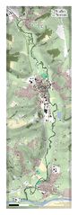
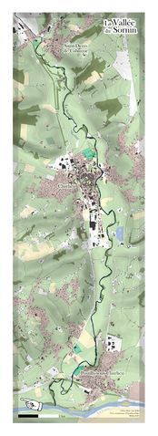
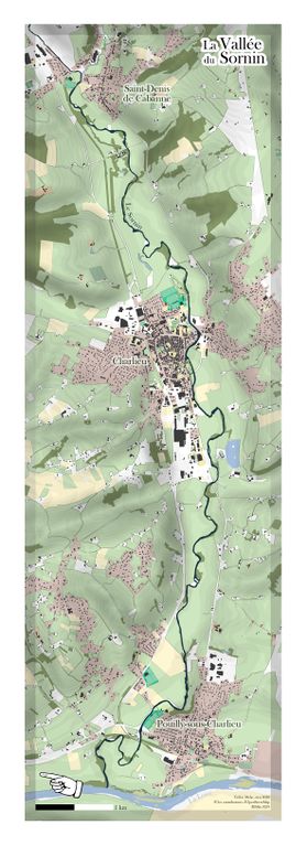
Map of La Vallée du Sornin, France, created by User:CapitaineMoustache using QGIS and Adobe Illustrator
Originally shared on reddit.com/r/openstreetmap.
On QGIS, I highly recommand the QuickOSM plugin and Charles Millet style which allows to quickly make vector maps with OSMCarto style on QGIS.
Sornin is river in france here: https://www.openstreetmap.org/#map=14/46.1617/4.1654
Licensing
Creative Commons User:CapitaineMoustache. Uploaded by permission [1]
![]()
![]()
![]()
This work is licensed under the Creative Commons Attribution-ShareAlike 4.0 License.
Attribution not specified as a parameter! THIS LICENSE ALWAYS REQUIRES ATTRIBUTION! Use {{CC-BY-SA-4.0|Attribution, typically name of author}} See Template:CC-BY-SA-4.0 for full description this template should be used.
Attribution not specified as a parameter! THIS LICENSE ALWAYS REQUIRES ATTRIBUTION! Use {{CC-BY-SA-4.0|Attribution, typically name of author}} See Template:CC-BY-SA-4.0 for full description this template should be used.
File history
Click on a date/time to view the file as it appeared at that time.
| Date/Time | Thumbnail | Dimensions | User | Comment | |
|---|---|---|---|---|---|
| current | 20:34, 8 May 2020 | 2,363 × 6,497 (2.91 MB) | Harry Wood (talk | contribs) | La Vallee du Sornin by User:CapitaineMoustache Cedric Melac |
You cannot overwrite this file.
File usage
The following 9 pages use this file: