File:Lexington Area Mappers.jpeg
Jump to navigation
Jump to search


Size of this preview: 800 × 563 pixels. Other resolutions: 320 × 225 pixels | 640 × 451 pixels | 1,037 × 730 pixels.
Original file (1,037 × 730 pixels, file size: 222 KB, MIME type: image/jpeg)
Summary
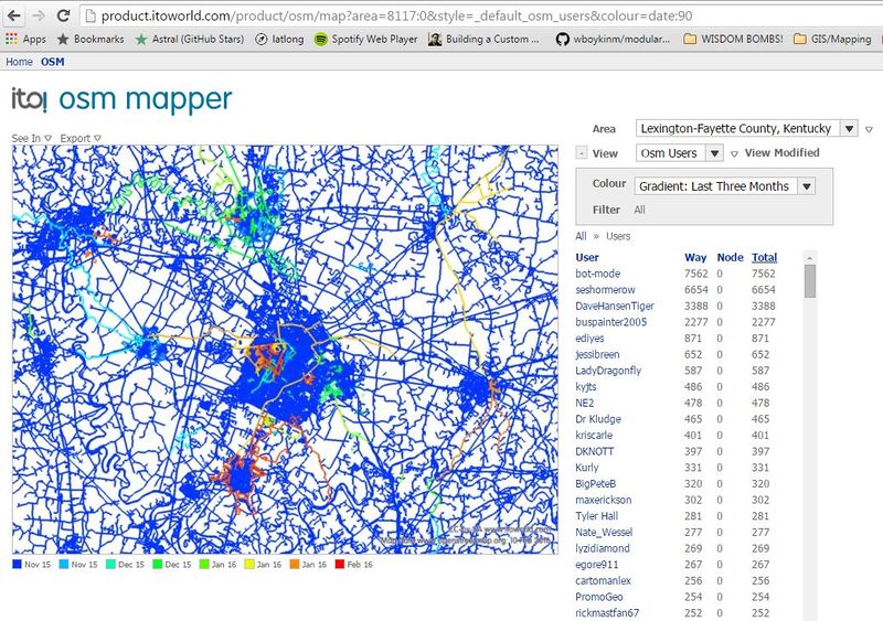
Lexington area mappers from the 3 months prior to 2/23/2016
Licensing
| Contains map data © OpenStreetMap contributors, made available under the terms of the Open Database License (ODbL).
The ODbL does not require any particular license for maps produced from ODbL data, produced maps may be subject also to other licences. |
File history
Click on a date/time to view the file as it appeared at that time.
| Date/Time | Thumbnail | Dimensions | User | Comment | |
|---|---|---|---|---|---|
| current | 19:12, 23 February 2016 | | 1,037 × 730 (222 KB) | Buspainter2005 (talk | contribs) | Lexington area mappers from the 3 months prior to 2/23/2016 |
You cannot overwrite this file.
File usage
There are no pages that use this file.