File:Line area connection-FR.png
Jump to navigation
Jump to search

No higher resolution available.
Line_area_connection-FR.png (300 × 300 pixels, file size: 29 KB, MIME type: image/png)
Summary
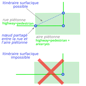
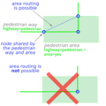
Connecting a line to a polygon to enable open area routing
Other versions
Version in English

Licensing
- This media file was uploaded by author of the work and its copyright holder.
![]()
![]()
![]()
This work is licensed under the Creative Commons Attribution-ShareAlike 4.0 License.
Attribution: Carto'Cité
Attribution: Carto'Cité
File history
Click on a date/time to view the file as it appeared at that time.
| Date/Time | Thumbnail | Dimensions | User | Comment | |
|---|---|---|---|---|---|
| current | 08:34, 20 May 2019 | | 300 × 300 (29 KB) | Carto'Cité (talk | contribs) | |
| 08:36, 8 May 2019 | 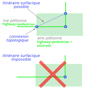 | 300 × 300 (28 KB) | Carto'Cité (talk | contribs) | Connecting a line to a polygon to enable open area routing |
You cannot overwrite this file.
File usage
The following 3 pages use this file: