File:Linz topo50 soakhole.png
Jump to navigation
Jump to search
No higher resolution available.
Linz_topo50_soakhole.png (424 × 211 pixels, file size: 26 KB, MIME type: image/png)
Summary
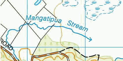
LINZ Topo50 symbol for a soakhole.
CC BY 4.0 Land Information New Zealand.
Licensing
![]()
![]()
This work is licensed under the Creative Commons Attribution 4.0 License.
File history
Click on a date/time to view the file as it appeared at that time.
| Date/Time | Thumbnail | Dimensions | User | Comment | |
|---|---|---|---|---|---|
| current | 04:15, 5 March 2021 | | 424 × 211 (26 KB) | Adavidson (talk | contribs) | LINZ Topo50 symbol for a soakhole. CC BY 4.0 Land Information New Zealand. |
You cannot overwrite this file.
File usage
The following 3 pages use this file: