File:Longest routing.png
Jump to navigation
Jump to search


Size of this preview: 800 × 550 pixels. Other resolutions: 320 × 220 pixels | 640 × 440 pixels | 1,032 × 709 pixels.
Original file (1,032 × 709 pixels, file size: 164 KB, MIME type: image/png)
Summary
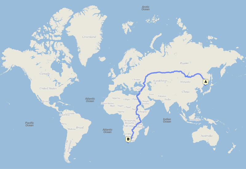
Probably the longest routing available on any public engine.
From Cloudmade
Licensing
![]()
This media file does not have sufficient information on its copyright status. If you have created this file yourself, or the file is available under some open licence allowing its use on OSM Wiki or the file is in the public domain, you can edit the file description page to license it under one of the allowed licences. If you did not create it and it is not in the public domain, you must ask the copyright holder for permission to release it under one of the allowed licenses. Wiki:Media file license chart may be helpful to find a suitable licence.
Files without licences marked with this template are listed in Category:Media without a license or one of its subcategories. If the file is without a known open licence: ask its uploader to clarify situation or find a replacement and mark this file with {{Superseded by Commons}} and replace its uses.
Files without licences marked with this template are listed in Category:Media without a license or one of its subcategories. If the file is without a known open licence: ask its uploader to clarify situation or find a replacement and mark this file with {{Superseded by Commons}} and replace its uses.
If uploader was notified this month: use {{No licence|subcategory=uploader notified 2024, April}} - to put media into Category:Media without a license - uploader notified 2024, April and mark image as one where uploader was notified.
This is a Featured image, which means that it has been identified as one of the best examples of OpenStreetMap mapping, or that it provides a useful illustration of the OpenStreetMap project. If you know another image of similar quality, you can nominate it on Featured image proposals.
Front-page image for week 21 of 2011 (23–29 May).
- Image descriptions
- Deutsch : 23448 km von Wladiwostok nach Südafrika. 301 Stunden mit dem Auto. Das ist wahrscheinlich die längste Route, die bei öffentlichen Routenplanern verfügbar ist. Erzeugt wurde sie von Cloudmade mit den Daten von OSM.
- eesti : 23448 km Vladivostokist Lõuna-Aafrikasse. 301 tundi autoga. Tõenäoliselt kõige pikem marsruut, mida võib teekonnaplaneerijatest leida. Projektist Cloudmade OSMi andmete põhjal.
- English : 23448 km from Vladivostok to South Africa. 301 hrs by car. Probably the longest routing available on any public routing engine. From Cloudmade with OSM data.
- français : 23448 km de Vladivostok à l'Afrique du Sud. 301 heures en voiture. Probablement le routage le plus long disponible sur tous les moteur de routage publiques. Par Cloudmade avec les données OSM.
- italiano : 23448 km da Vladivostok al Sud Africa. 301 ore in automobile. Probabilmente è il percorso più lungo disponibile su qualsiasi motore di navigazione pubblico. Da Cloudmade con dati OSM.
- русский : Маршрут длиной 23 448 км (301 час езды) от Владивостока до Южной Африки. Сгенерирован на проекте CloudMade с использованием данных OSM. Это один из самых длинных путей, который только можно получить, используя публично доступный движок прокладки маршрутов. Но можно и длиннее. Попробуйте найти действительно самый длинный путь!
- 日本語 : 自動車でウラジオストックから南アフリカに至る 23448km,301時間のルート。おそらく既存のルート検索結果のうち最長のもの。これはOSMデータを用いるCloudmade の結果。
- 中文(繁體) : 從俄羅斯海參威 (Vladivostok)到南非23448 公里的路程,301鐘頭的車程。也許是目前市面上導航引擎最長的紀錄。是Cloudmade依據OSM資料所開發的。
File history
Click on a date/time to view the file as it appeared at that time.
| Date/Time | Thumbnail | Dimensions | User | Comment | |
|---|---|---|---|---|---|
| current | 23:16, 18 May 2011 | | 1,032 × 709 (164 KB) | FrViPofm (talk | contribs) | |
| 21:57, 18 May 2011 | 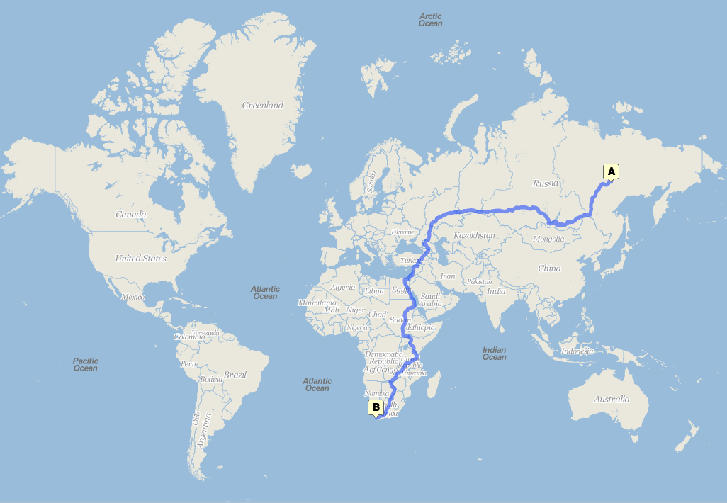 | 1,026 × 710 (210 KB) | FrViPofm (talk | contribs) | Probably the longest routing available on any public engine. From [http://maps.cloudmade.com/?lat=40.178873&lng=-48.515625&zoom=2&directions=62.63092875898299,134.82627868652344,-33.9433599465788,18.4130859375&travel=car&styleId=1&opened_tab=1 Cloudmade] |
You cannot overwrite this file.
File usage
The following 10 pages use this file: