File:Malapascua Island 2010-01-29.png
Jump to navigation
Jump to search

Size of this preview: 458 × 599 pixels. Other resolutions: 183 × 240 pixels | 367 × 480 pixels | 924 × 1,209 pixels.
Original file (924 × 1,209 pixels, file size: 50 KB, MIME type: image/png)
Summary
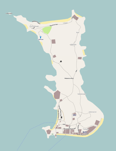
| Description | OSM default Mapnik rendering of the resort island of Malapascua in Cebu as of January 29, 2010. Practically all of the mapping on this island was done by Plutocrat. |
|---|---|
| Author | seav |
| Source | OSM (Mapnik layer) (permalink to map) |
| Date | 2010-01-29 |
| Permission | CC-BY-SA 3.0 |
Licensing
Licensing
![]()
![]()
![]()
This screenshot contains OpenStreetMap Carto rendering.
The OpenStreetMap Carto map style is made available under the Creative Commons CC-0 1.0 Universal Public Domain Dedication.
- Attribution to the map data:
![]()
Contains map data © OpenStreetMap contributors, made available under the terms of the Creative Commons Attribution-ShareAlike 2.0 (CC-BY-SA-2.0).
File history
Click on a date/time to view the file as it appeared at that time.
| Date/Time | Thumbnail | Dimensions | User | Comment | |
|---|---|---|---|---|---|
| current | 07:15, 29 January 2010 | | 924 × 1,209 (50 KB) | Seav (talk | contribs) | ==Information== {{Information |Description = OSM default Mapnik rendering of the resort island of Malapascua in Cebu as of January 29, 2010. Practically all of the mapping on this island was done by [http://www.openstreetmap.org/user/Plutocrat Plutocra |
You cannot overwrite this file.
File usage
The following page uses this file: