File:Mapathon-la-guajira.jpg
Jump to navigation
Jump to search


Size of this preview: 800 × 512 pixels. Other resolutions: 320 × 205 pixels | 640 × 410 pixels | 1,024 × 655 pixels | 1,256 × 804 pixels.
Original file (1,256 × 804 pixels, file size: 334 KB, MIME type: image/jpeg)
Summary
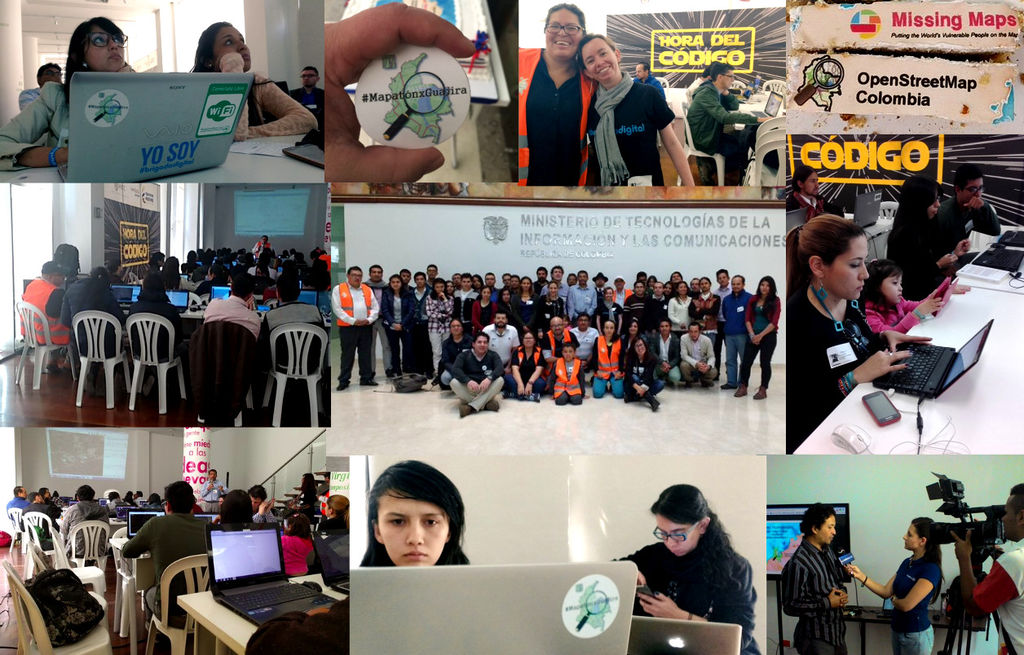
Mapathon La Guajira (Colombia) - 20/01/2016
This is a Featured image, which means that it has been identified as one of the best examples of OpenStreetMap mapping, or that it provides a useful illustration of the OpenStreetMap project. If you know another image of similar quality, you can nominate it on Featured image proposals.
Front-page image for week 5 of 2016 (1–7 Feb.).
- Image descriptions
- asturianu : El mes pasáu aconceyaron en Bogotà los mapeadores pa una actividá del proyeutu OpenStreetMap Colombia/Missing Maps p'ayudar a poner nel mapa al pueblu Wayuu, faciendo'l mapa detalláu de la península de «La Guajira». Pa saber más ver el blog de OpenStreetMap Colombia (en castellanu).
- English : Last month mappers gathered in Bogota, for an OpenStreetMap Colombia/Missing Maps Project event to help put the Wayuu people on the map, by mapping details of the "La Guajira" peninsula. Read more on the OpenStreetMap Colombia blog.
- italiano : Il mese scorso dei mappatori si sono riuniti Bogotà per un evento del progetto OpenStreetMap Colombia/Missing Maps per aiutare il popolo Wayuu sulla mappa, mappando i dettagli della penisola "La Guajira". Per saperne di più leggere il blog di OpenStreetMap Colombia (in spagnolo).
- русский : В конце января в Баготе (столице Колумбии) прошла встреча волонтёров ОСМа. Целью мероприятия было улучшение карты полуострова Гуахира, места обитания народа Вайю. Подробности — в блоге местного сообщества.
- 中文(简体) : 上个月图客聚集在波哥大,参与 OpenStreetMap 哥伦比亚/Missing Maps 计画活动,藉由绘制瓜希拉半岛来帮助瓦尤人在地图上找到自身存在。详情可见开放街图哥伦比亚社群部落格。
- 中文(繁體) : 上個月圖客聚集在波哥大,參與 OpenStreetMap 哥倫比亞/Missing Maps 計畫活動,藉由繪製瓜希拉半島來幫助瓦尤人在地圖上找到自身存在。詳情可見開放街圖哥倫比亞社群部落格。
Licensing
![]()
![]()
![]()
This work is licensed under the Creative Commons Attribution-ShareAlike 3.0 License.
Attribution not specified as a parameter! THIS LICENSE ALWAYS REQUIRES ATTRIBUTION! Use {{CC-BY-SA-3.0|Attribution, typically name of author}} See Template:CC-BY-SA-3.0 for full description how this template should be used.
Attribution not specified as a parameter! THIS LICENSE ALWAYS REQUIRES ATTRIBUTION! Use {{CC-BY-SA-3.0|Attribution, typically name of author}} See Template:CC-BY-SA-3.0 for full description how this template should be used.
File history
Click on a date/time to view the file as it appeared at that time.
| Date/Time | Thumbnail | Dimensions | User | Comment | |
|---|---|---|---|---|---|
| current | 19:47, 22 January 2016 | | 1,256 × 804 (334 KB) | Wille (talk | contribs) | Mapathon La Guajira (Colombia) - 20/01/2016 |
You cannot overwrite this file.