File:Meadow Lock, Hatherton Canal, Four Crosses, Staffordshire - geograph.org.uk - 790933.jpg
Jump to navigation
Jump to search


Size of this preview: 461 × 600 pixels. Other resolutions: 184 × 240 pixels | 492 × 640 pixels.
Original file (492 × 640 pixels, file size: 147 KB, MIME type: image/jpeg)
This file and its description are from Wikimedia Commons.
Summary
| Description |
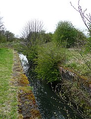
English: Meadow Lock, Hatherton Canal, Four Crosses, Staffordshire This is the derelict Meadow Lock looking towards the missing bottom gates. When the lock is restored, the change in water level will only be a metre or so. There were sixteen locks on the Hatherton Canal when it closed in 1955. This is No 3 from Hatherton Junction. Some of the locks (at Churchbridge) were completely dismantled, so the required work involved in rebuilding, renovating and restoration on this canal is considerable. Join the Trust! http://www.lhcrt.org.uk |
| Date | |
| Source | From geograph.org.uk |
| Author | Roger Kidd |
| Attribution (required by the license) | Roger Kidd / Meadow Lock, Hatherton Canal, Four Crosses, Staffordshire / |
| Camera location | | View this and other nearby images on: OpenStreetMap |
|---|
_heading:292.00&language=en)
| Object location | | View this and other nearby images on: OpenStreetMap |
|---|
_heading:292.00&language=en)
Licensing

|
This image was taken from the Geograph project collection. See this photograph's page on the Geograph website for the photographer's contact details. The copyright on this image is owned by Roger Kidd and is licensed for reuse under the Creative Commons Attribution-ShareAlike 2.0 license.
|
This file is licensed under the Creative Commons Attribution-Share Alike 2.0 Generic license.
Attribution: Roger Kidd
- You are free:
- to share – to copy, distribute and transmit the work
- to remix – to adapt the work
- Under the following conditions:
- attribution – You must give appropriate credit, provide a link to the license, and indicate if changes were made. You may do so in any reasonable manner, but not in any way that suggests the licensor endorses you or your use.
- share alike – If you remix, transform, or build upon the material, you must distribute your contributions under the same or compatible license as the original.
File history
Click on a date/time to view the file as it appeared at that time.
| Date/Time | Thumbnail | Dimensions | User | Comment | |
|---|---|---|---|---|---|
| current | 05:22, 20 February 2011 | | 492 × 640 (147 KB) | wikimediacommons>GeographBot | == {{int:filedesc}} == {{Information |description={{en|1=Meadow Lock, Hatherton Canal, Four Crosses, Staffordshire This is the derelict Meadow Lock looking towards the missing bottom gates. When the lock is restored, the change in water level will only be |
File usage
The following 5 pages use this file: