File:Melbourne NearMap November 10.png
Jump to navigation
Jump to search

No higher resolution available.
Melbourne_NearMap_November_10.png (249 × 299 pixels, file size: 83 KB, MIME type: image/png)
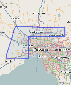
NearMap imagery coverage for Melbourne, Australia as of November 10, 2009
![]()
Contains map data © OpenStreetMap contributors, made available under the terms of the Creative Commons Attribution-ShareAlike 2.0 (CC-BY-SA-2.0).
File history
Click on a date/time to view the file as it appeared at that time.
| Date/Time | Thumbnail | Dimensions | User | Comment | |
|---|---|---|---|---|---|
| current | 12:36, 10 November 2009 | | 249 × 299 (83 KB) | Lakeyboy (talk | contribs) | NearMap imagery coverage for Melbourne, Australia as of November 10, 2009 |
You cannot overwrite this file.
File usage
There are no pages that use this file.