File:MeridaVenezuela.png
Jump to navigation
Jump to search

Size of this preview: 800 × 437 pixels. Other resolutions: 320 × 175 pixels | 640 × 350 pixels | 1,065 × 582 pixels.
Original file (1,065 × 582 pixels, file size: 319 KB, MIME type: image/png)
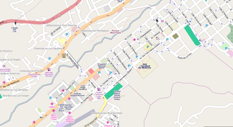
OSM map of Merida (map), Venezuela. Data by Fundacion GeoHorizontes de Venezuela. Data collected by HernanRamirez.
This is a modified version of File:MeridaVenezuela.jpg Now showing the latest data (including a river added!), without the map controls (since this is not a screen-shot illustration of any particular web mapping display), and saved as png instead of jpeg to avoid compression artefacts.
This is a Featured image, which means that it has been identified as one of the best examples of OpenStreetMap mapping, or that it provides a useful illustration of the OpenStreetMap project. If you know another image of similar quality, you can nominate it on Featured image proposals.
Front-page image for week 39 of 2010 (27 Sep. – 3 Oct.).
- Image descriptions
- eesti : Merida[1] (Venezuela) OSMi kaart. Andmed Fundacion GeoHorizontes de Venezuelalt, kogunud HernanRamirez.
- English : OSM map of Merida[2], Venezuela. Data by Fundacion GeoHorizontes de Venezuela. Data collected by HernanRamirez.
- français : Carte OSM de Merida[3], au Vénézuéla. Données de la Fundacion GeoHorizontes de Venezuela, collectées par HernanRamirez.
- italiano : Mappa OSM della città di Merida[4], Venezuela. Dati resi disponibili dalla Fundacion GeoHorizontes de Venezuela. Dati raccolti dall'utente HernanRamirez.
- lietuvių : Miesto Merida[5] Venesueloje žemėlapis. Duomenys pagal "Fundacion GeoHorizontes de Venezuela". Duomenis surinko HernanRamirez.
- Nederlands : OSM kaar van Merida[6], Venezuela. Data afkomstig van Fundacion GeoHorizontes de Venezuela. Data verzameld door HernanRamirez.
- polski : Mapa OSM Meridy[7] (Wenezuela). Dane z wenezuelskiej Fundacji GeoHorizontes. Zebrane przez HernanRamireza.
- português : Mapa de Merida[8], Venezuela, no OSM. Dados da Fundacion GeoHorizontes de Venezuela. Dados coletados por HernanRamirez.
- русский : Карта Мериды, Венесуэла. Данные получены от «фонда GeoHorizontes de Venezuela» участником HernanRamirez.
File history
Click on a date/time to view the file as it appeared at that time.
| Date/Time | Thumbnail | Dimensions | User | Comment | |
|---|---|---|---|---|---|
| current | 18:24, 30 September 2010 | | 1,065 × 582 (319 KB) | Harry Wood (talk | contribs) | updated version (replacement?) for File:MeridaVenezuela.jpg |
You cannot overwrite this file.