File:MichiganLeft Intersection.PNG
Jump to navigation
Jump to search

Size of this preview: 462 × 600 pixels. Other resolutions: 185 × 240 pixels | 500 × 649 pixels.
Original file (500 × 649 pixels, file size: 448 KB, MIME type: image/png)
Summary
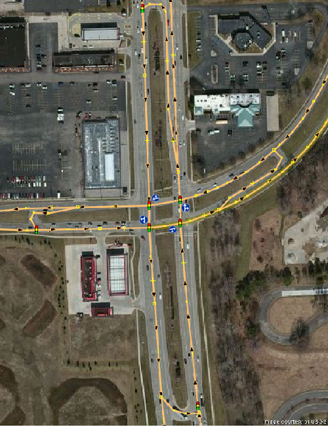
Example of a Michigan Left. Location is the intersection of Mound Road and 13 Mile Road (42.520689, -83.04711) in Detroit Metro Area
Licensing
![]()
This file is a screenshot of the software JOSM, with imagery in background. It may include OpenStreetMap data, in such case ODbL license also applies.
![]()
"JOSM" (Java OpenStreetMap Editor – josm.openstreetmap.de) is free software released under the terms of the GNU General Public License as published by the Free Software Foundation; either version 2 of the license, or any later version.
License of imagery not specified! [→ template]
Data displayed: minimalFile history
Click on a date/time to view the file as it appeared at that time.
| Date/Time | Thumbnail | Dimensions | User | Comment | |
|---|---|---|---|---|---|
| current | 01:21, 15 January 2014 | | 500 × 649 (448 KB) | KristenK (talk | contribs) | Example of a Michigan Left. Location is the intersection of Mound Road and 13 Mile Road (42.520689, -83.04711) in Detroit Metro Area |
You cannot overwrite this file.
File usage
The following page uses this file: