File:Multipolygon-example forest-2water-scrub-boundary-highway-3farmland.svg
Jump to navigation
Jump to search


Size of this PNG preview of this SVG file: 440 × 420 pixels. Other resolutions: 251 × 240 pixels | 503 × 480 pixels | 805 × 768 pixels | 1,073 × 1,024 pixels.
Original file (SVG file, nominally 440 × 420 pixels, file size: 35 KB)
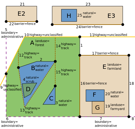
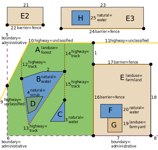
Multipolygon example: forest with 2 water, one with scrub. boundary, highway. 3 farmland, one with farmyard and water.
![]()
This media file does not have sufficient information on its copyright status. If you have created this file yourself, or the file is available under some open licence allowing its use on OSM Wiki or the file is in the public domain, you can edit the file description page to license it under one of the allowed licences. If you did not create it and it is not in the public domain, you must ask the copyright holder for permission to release it under one of the allowed licenses. Wiki:Media file license chart may be helpful to find a suitable licence.
Files without licences marked with this template are listed in Category:Media without a license or one of its subcategories. If the file is without a known open licence: ask its uploader to clarify situation or find a replacement and mark this file with {{Superseded by Commons}} and replace its uses.
Files without licences marked with this template are listed in Category:Media without a license or one of its subcategories. If the file is without a known open licence: ask its uploader to clarify situation or find a replacement and mark this file with {{Superseded by Commons}} and replace its uses.
If uploader was notified this month: use {{No licence|subcategory=uploader notified 2024, April}} - to put media into Category:Media without a license - uploader notified 2024, April and mark image as one where uploader was notified.
File history
Click on a date/time to view the file as it appeared at that time.
| Date/Time | Thumbnail | Dimensions | User | Comment | |
|---|---|---|---|---|---|
| current | 03:03, 17 June 2012 | | 440 × 420 (35 KB) | Willi2006 (talk | contribs) | Removed touching inner and outer as discussed. |
| 08:21, 28 August 2010 |  | 440 × 420 (35 KB) | Willi2006 (talk | contribs) | Using same colors as Mapnik. | |
| 13:49, 1 August 2010 |  | 440 × 420 (35 KB) | Willi2006 (talk | contribs) | Problem with previous upload. | |
| 12:22, 1 August 2010 |  | 440 × 410 (32 KB) | Willi2006 (talk | contribs) | Correcting text size. | |
| 12:09, 1 August 2010 |  | 440 × 410 (32 KB) | Willi2006 (talk | contribs) | Correcting tagging | |
| 10:28, 1 August 2010 |  | 440 × 410 (33 KB) | Willi2006 (talk | contribs) | Highways renumbered. Lake added | |
| 09:00, 31 July 2010 |  | 430 × 410 (32 KB) | Willi2006 (talk | contribs) | Enlarging page size a little | |
| 08:41, 31 July 2010 |  | 420 × 410 (32 KB) | Willi2006 (talk | contribs) | Increasing text size from 8 to 10 pt | |
| 07:39, 31 July 2010 |  | 400 × 400 (29 KB) | Willi2006 (talk | contribs) | Minor enhancements. | |
| 07:18, 31 July 2010 |  | 400 × 400 (29 KB) | Willi2006 (talk | contribs) | Multipolygon example: forest with 2 water, one with scrub. boundary, highway. 3 farmland, one with farmyard and water. |
You cannot overwrite this file.
File usage
The following 7 pages use this file: