File:National Geographic Slovenija-using OSM-October 2018.jpg
Jump to navigation
Jump to search


Size of this preview: 800 × 600 pixels. Other resolutions: 320 × 240 pixels | 640 × 480 pixels | 1,024 × 768 pixels | 1,280 × 960 pixels | 2,000 × 1,500 pixels.
Original file (2,000 × 1,500 pixels, file size: 724 KB, MIME type: image/jpeg)
Summary
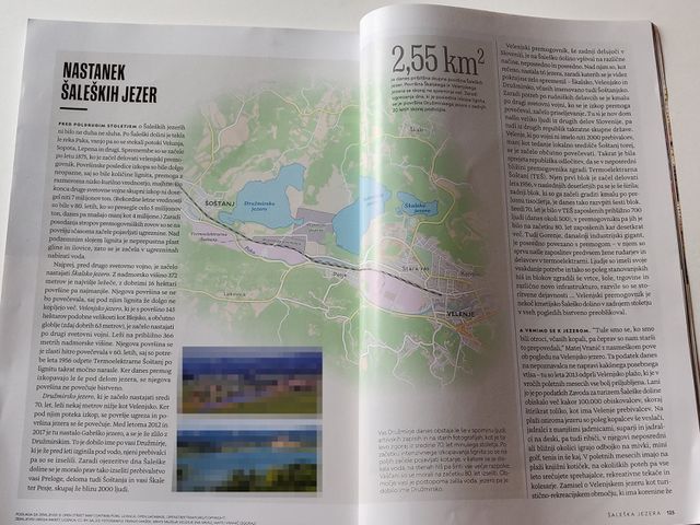
In the October 2018 printed edition National Geographic Slovenia used the OpenStreetMap map to illustrate an article about Šalek lakes, showcasing the importance of Slovenia Landcover Import project and giving nice attribution to OSM.
Published under CC-BY-SA 2.0 with explicit written permission from the publisher Založba Rokus Klett, d.o.o.
Note: 2 smaller photos are pixelated because authors / copyright holders approved publishing in OSM, but not explicitly with an open licence.
Licensing
![]()
![]()
![]()
This work is licensed under the Creative Commons Attribution-ShareAlike 2.0 License.
Attribution not specified as a parameter! THIS LICENSE ALWAYS REQUIRES ATTRIBUTION! Use {{CC-BY-SA-2.0|Attribution, typically name of author}} See Template:CC-BY-SA-2.0 for full description how this template should be used.
Note, there is
There is also
Attribution not specified as a parameter! THIS LICENSE ALWAYS REQUIRES ATTRIBUTION! Use {{CC-BY-SA-2.0|Attribution, typically name of author}} See Template:CC-BY-SA-2.0 for full description how this template should be used.
Note, there is
{{CC-BY-SA-2.0 OpenStreetMap}} for files based on old OSM map data, before the license change made on 2012-09-12.There is also
{{OSM Carto screenshot||old_license}} for files based on old OSM map data, before the license change made on 2012-09-12, created using OSM Carto map style.
File history
Click on a date/time to view the file as it appeared at that time.
| Date/Time | Thumbnail | Dimensions | User | Comment | |
|---|---|---|---|---|---|
| current | 12:15, 23 October 2018 | | 2,000 × 1,500 (724 KB) | Stefanb (talk | contribs) | In the October 2018 printed edition [http://www.nationalgeographic.si/ National Geographic Slovenia] used the OpenStreetMap map to illustrate [http://www.nationalgeographic.si/index.php?i=452 an article] about [https://www.openstreetmap.org/#map=14/46.... |
You cannot overwrite this file.
File usage
The following 13 pages use this file:
- Featured images/Oct-Dec 2018
- List of featured images/2018
- Printed maps
- Pt:Featured images/Oct-Dec 2018
- Zh-hans:Featured images/Oct-Dec 2018
- Zh-hant:Featured images/Oct-Dec 2018
- Template:Iotw image/2018-50
- DE:Featured images/Oct-Dec 2018
- FR:Featured images/Oct-Dec 2018
- ES:Featured images/Oct-Dec 2018
- ES:Mapas impresos
- IT:Featured images/Oct-Dec 2018
- RU:Printed maps