File:NopHikingMap.png
Jump to navigation
Jump to search


Size of this preview: 592 × 600 pixels. Other resolutions: 237 × 240 pixels | 628 × 636 pixels.
Original file (628 × 636 pixels, file size: 373 KB, MIME type: image/png)
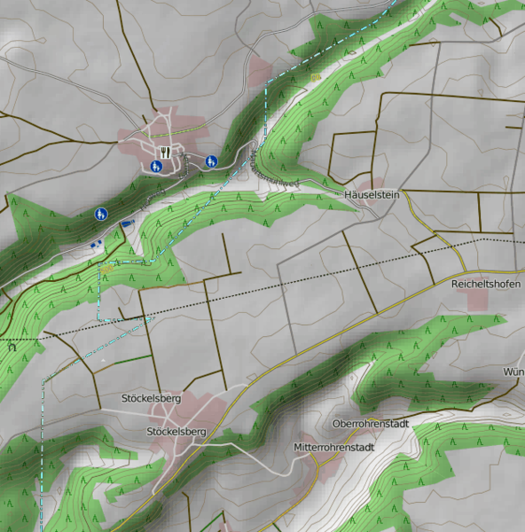
This is a Featured image, which means that it has been identified as one of the best examples of OpenStreetMap mapping, or that it provides a useful illustration of the OpenStreetMap project. If you know another image of similar quality, you can nominate it on Featured image proposals.
Front-page image for week 7 of 2009 (9–15 Feb.).
- Image descriptions
- Deutsch : Eine Wanderkarte ist verfügbar, sie zeigt die Reliefkarten und die Konturen der Landschaften und die hervorgehobende Wege und Pfade. (Aktuell:DE:OSMC Reitkarte)
- English : A hiking map is available, showing the relief and contours of the landscape, and highlighting paths and trails (Note: Now seems to be described at DE:OSMC Reitkarte)
- italiano : È disponibile una mappa per escursionisti che mostra i rilievi e le curve di livello del paesaggio e evidenzia sentieri e piste (Nota: ora sembra che sia descritta in OSMC Reitkarte)
- português : Mapas para trilhas disponíveis, mostrando o relevo e contornos do terreno, e destacando trilhas (Nota: Agora parece ser descrito em DE:OSMC Reitkarte)
Now seems to be described at DE:OSMC Reitkarte
File history
Click on a date/time to view the file as it appeared at that time.
| Date/Time | Thumbnail | Dimensions | User | Comment | |
|---|---|---|---|---|---|
| current | 20:08, 22 December 2008 | | 628 × 636 (373 KB) | Ojw (talk | contribs) |
You cannot overwrite this file.