File:OSM-node-density-map-HD-2013.png
Jump to navigation
Jump to search

Size of this preview: 600 × 600 pixels. Other resolutions: 240 × 240 pixels | 480 × 480 pixels | 768 × 768 pixels | 1,024 × 1,024 pixels | 2,048 × 2,048 pixels | 8,192 × 8,192 pixels.
Original file (8,192 × 8,192 pixels, file size: 507 KB, MIME type: image/png)
Summary
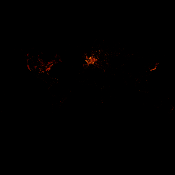
OpenStreetMap node density as of 2013-05-22 based on Frederik's densely mapped locations analysis. Each pixel represents one tile at zoom-level 13. Read more - howto.
Licensing
based on © OpenStreetMap data (ODbL).
![]()
![]()
![]()
This work is licensed under the Creative Commons Attribution-ShareAlike 2.0 License.
Attribution not specified as a parameter! THIS LICENSE ALWAYS REQUIRES ATTRIBUTION! Use {{CC-BY-SA-2.0|Attribution, typically name of author}} See Template:CC-BY-SA-2.0 for full description how this template should be used.
Note, there is
There is also
Attribution not specified as a parameter! THIS LICENSE ALWAYS REQUIRES ATTRIBUTION! Use {{CC-BY-SA-2.0|Attribution, typically name of author}} See Template:CC-BY-SA-2.0 for full description how this template should be used.
Note, there is
{{CC-BY-SA-2.0 OpenStreetMap}} for files based on old OSM map data, before the license change made on 2012-09-12.There is also
{{OSM Carto screenshot||old_license}} for files based on old OSM map data, before the license change made on 2012-09-12, created using OSM Carto map style.
see also


File history
Click on a date/time to view the file as it appeared at that time.
| Date/Time | Thumbnail | Dimensions | User | Comment | |
|---|---|---|---|---|---|
| current | 00:15, 2 July 2013 | | 8,192 × 8,192 (507 KB) | Tyr (talk | contribs) | fixed minor glitch at the equator (empty 1px line) |
| 19:31, 27 June 2013 |  | 8,192 × 8,192 (1.02 MB) | Tyr (talk | contribs) | reduced file size | |
| 17:36, 27 June 2013 |  | 8,192 × 8,192 (1.59 MB) | Tyr (talk | contribs) | tbd |
You cannot overwrite this file.
File usage
The following 3 pages use this file: