File:OSM Carto area pedestrian.png
Jump to navigation
Jump to search

No higher resolution available.
OSM_Carto_area_pedestrian.png (220 × 220 pixels, file size: 10 KB, MIME type: image/png)
Summary
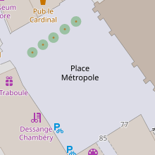
| Description | Rendering of a pedestrian area with OSM Carto (https://www.openstreetmap.org/way/22177520#map=19/45.56495/5.92259) |
|---|---|
| Author | OSM contributors |
| Source | own work |
Licensing
![]()
![]()
This screenshot contains OpenStreetMap Carto rendering.
The OpenStreetMap Carto map style is made available under the Creative Commons CC-0 1.0 Universal Public Domain Dedication.
- Attribution to the map data:
| Contains map data © OpenStreetMap contributors, made available under the terms of the Open Database License (ODbL).
The ODbL does not require any particular license for maps produced from ODbL data, produced maps may be subject also to other licences. |
File history
Click on a date/time to view the file as it appeared at that time.
| Date/Time | Thumbnail | Dimensions | User | Comment | |
|---|---|---|---|---|---|
| current | 20:41, 5 November 2021 | | 220 × 220 (10 KB) | Maro21 (talk | contribs) | update the image with the current rendering |
| 17:52, 26 August 2008 |  | 220 × 220 (9 KB) | Sletuffe (talk | contribs) | Rendering of a pedestrian area with mapnik |
You cannot overwrite this file.
File usage
More than 100 pages use this file. The following list shows the first 100 pages that use this file only. A full list is available.
- Ar:Properties
- Ast:Map Features
- Az:Map Features
- Az:Properties
- Bg:Map Features
- Cs:Key:area
- Cs:Map Features2
- Cs:Vlastnosti
- Da:Map Features
- Da:Properties
- El:Map Features
- Eo:Map Features
- Fa:Key:area
- Fa:Map Features
- Fi:Kartan ominaisuudet
- Fi:Ominaisuudet
- He:Map Features
- Hu:Map Features
- Hu:Properties
- Id:Map Features
- Id:Properties
- Key:area
- Lv:Map Features
- Map features
- Ne:Map Features
- Pl:Key:area
- Pl:Właściwości
- Properties
- Pt:Key:area
- Pt:Properties
- Ro-md:Map Features
- Ro:Map Features
- Sr:Map Features
- Sv:Key:area
- Sv:Map Features
- Tag:highway=pedestrian
- Uk:Key:area
- Uk:Properties
- Zh-hans:Map Features
- Zh-hant:Properties
- User:Chillly/Simple Map Features
- Wiki:Files used by data items/3
- File:Mapnik area pedestrian.png (file redirect)
- Map features
- Sv:Map Features
- Key:area
- Ro:Map Features
- Da:Map Features
- Tag:highway=pedestrian
- Hu:Map Features
- Fi:Kartan ominaisuudet
- Template:Map Features:properties
- User:Chillly/Simple Map Features
- Ro-md:Map Features
- Bg:Map Features
- Lv:Map Features
- Template:DE:Map Features:properties
- He:Map Features
- Template:JA:Map Features:properties
- Eo:Map Features
- Template:RU:Map Features:properties
- Template:IT:Map Features:properties
- Template:Pl:Map Features:properties
- Template:FR:Map Features:properties
- Template:Ar:Map Features:properties
- Template:Hu:Map Features:properties
- JA:Tag:highway=pedestrian
- Template:Fi:Map Features:properties
- Template:Ar:Map Features:properties
- Template:Az:Map Features:properties
- Template:Cs:Map Features:properties
- Template:DE:Map Features:properties
- Template:Da:Map Features:properties
- Template:Et:Map Features:properties
- Template:FR:Map Features:properties
- Template:Fi:Map Features:properties
- Template:Generic:ES:Map Features:properties
- Template:Hu:Map Features:properties
- Template:IT:Map Features:properties
- Template:Id:Map Features:properties
- Template:JA:Map Features:properties
- Template:Map Features:properties
- Template:NL:Map Features:properties
- Template:Pl:Map Features:properties
- Template:Pt:Map Features:properties
- Template:RU:Map Features:properties
- Template:Uk:Map Features:properties
- Template:Zh-hant:Map Features:properties
- DE:Eigenschaften
- DE:Key:area
- FR:Key:area
- FR:Propriétés
- ES:Key:area
- ES:Propiedades
- ES:Tag:area=yes
- NL:Properties
- RU:Key:area
- RU:Key:area:highway
- RU:Properties
- JA:Key:area
View more links to this file.