File:OpenOrienteeringMap of Ayala Center, Makati 2010-01-29.png
Jump to navigation
Jump to search


Size of this preview: 756 × 600 pixels. Other resolutions: 303 × 240 pixels | 605 × 480 pixels | 986 × 782 pixels.
Original file (986 × 782 pixels, file size: 112 KB, MIME type: image/png)
Summary
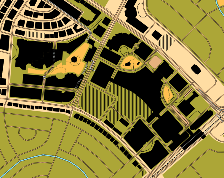
| Description | Pseud-O OpenOrienteeringMap of Ayala Center, Makati as of January 29, 2010. |
|---|---|
| Author | seav |
| Source | OpenOrienteeringMap (permalink to map) |
| Date | 2010-01-29 |
| Permission | CC-BY-SA 3.0 |
This is a Featured image, which means that it has been identified as one of the best examples of OpenStreetMap mapping, or that it provides a useful illustration of the OpenStreetMap project. If you know another image of similar quality, you can nominate it on Featured image proposals.
Front-page image for week 8 of 2010 (22–28 Feb.).
- Image descriptions
- čeština : Mapa Aylea centra renderovaná pomocí OpenOrienteeringMap.
- Deutsch : Rendering von Ayala Center in der OpenOrienteeringMap.
- English : OpenOrienteeringMap rendering of Ayala Center
- español : La vista del Ayala Center en OpenOrienteeringMap, un nuevo renderizado para los deportes de orientación
- français : Exemple de rendu OpenOrienteeringMap sur le Centre Ayala. Ce rendu utilise les codes proposés pour les cartes destinées aux courses d'orientation.
- italiano : Rendering di Ayala Center in OpenOrienteeringMap
- magyar : Tájfutáshoz használható térkép az Ayala Center-ről az OpenOrienteeringMap segítségével.
- polski : Ayala Center widoczne na OpenOrienteeringMap, nowych mapach do biegów na orientację
- português : Renderização do Ayala Center pelo OpenOrienteeringMap
- suomi : OpenOrienteeringMap on suunnistuskartta OpenStreetMap-tiedoista. Tässä Ayala, Makati, Filippiinit. Voit selata karttaa myös suoraan alkaen vaikkapa Turusta.
- македонски : Ајала-центарот исцртан со OpenOrienteeringMap
- русский : Айяла-центр на карте OpenOrienteeringMap, нарисованной по правилам карт для спортивного ориентирования.
Licensing
![]()
![]()
![]()
This work is licensed under the Creative Commons Attribution-ShareAlike 3.0 License.
Attribution: Screenshot by seav from OpenOrienteeringMap (permalink to map)
Attribution: Screenshot by seav from OpenOrienteeringMap (permalink to map)
![]()
Contains map data © OpenStreetMap contributors, made available under the terms of the Creative Commons Attribution-ShareAlike 2.0 (CC-BY-SA-2.0).
File history
Click on a date/time to view the file as it appeared at that time.
| Date/Time | Thumbnail | Dimensions | User | Comment | |
|---|---|---|---|---|---|
| current | 05:48, 29 January 2010 | | 986 × 782 (112 KB) | Seav (talk | contribs) | ==Information== {{Information |Description = Pseud-O OpenOrienteeringMap of Ayala Center, Makati as of January 29, 2010. |Source = OpenOrienteeringMap |Author = seav |Date = 2010-01-29 |Permission = CC-BY |
You cannot overwrite this file.
File usage
The following 16 pages use this file:
- Featured images/Jan-Mar 2010
- List of OSM-based services
- List of featured images/2010
- OpenOrienteeringMap
- Philippines/Featured images/2010
- Pt:List of OSM-based services
- Uk:List of OSM-based services
- Template:Iotw image/2010-8
- DE:Featured images/Jan-Mar 2010
- DE:List of OSM-based services
- FR:Featured images/Jan-Mar 2010
- ES:Lista de servicios basados en OSM
- ES:OpenOrienteeringMap
- IT:Featured images/Jan-Mar 2010
- NL:List of OSM-based services
- RU:List of OSM-based services