File:Opendata-dourados-ms.jpg
Original file (651 × 885 pixels, file size: 63 KB, MIME type: image/jpeg)
Summary
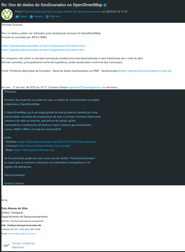
Authorization to use data from Dourados, Mato Grosso do Sul, Brazil.
Capture of the e-mail sent by the Municipal Planning Department (SEPLAN, from the Dourados City Council), where the use of data from the GeoDourados platform is authorized on OpenStreetMap.
Captura da mensagem de e-mail emitido pela Secretaria Municipal de Planejamento (SEPLAN, órgão da Prefeitura Municipal de Dourados), onde se autoriza o uso dos dados da plataforma GeoDourados no OpenStreetMap.
English
Message transcript and translated:
Date: 2022-03-14 11:47
From: Dourados City Hall Geoprocessing Center <geodourados@dourados.ms.gov.br>
To: Gustavo Soares
Dear Gustavo,
Yes, the data can be used to update the OpenStreetMap database.
Access layers via WFS and WMS
https://geodourados.dourados.ms.gov.br/geoserver/dourados/wms
https://geodourados.dourados.ms.gov.br/geoserver/dourados/wfs
For now, do not use the addresses numbers layer as it is currently out of date and will be replaced by April. Other layers, mainly street names, are updated according to municipal laws.
Source: Prefeitura Municipal de Dourados - Base de dados GeoDourados or PMD - GeoDourados (https://geodourados.dourados.ms.gov.br)
--
Regards,
Enio Alencar da Silva
Director | Geographer
Geoprocessing Department
SEPLAN - Municipal Planning Department
PMD - City Hall of Dourados-MS
On Fri., 11 Mar. on 2022 at 4:17 PM, Gustavo Soares wrote:
Dear,
I would like to ask if we can use GeoDourados data in the OpenStreetMap collaborative project
OpenStreetMap.org is an open license global map maintained by a volunteer community of mappers from around the world and provides data for hundreds of internet sites, mobile applications, humanitarian actions and institutions of various types including government agencies such as INDE and IBGE, and in the ConectaSUS App.
Links:
- Details: https://wiki.openstreetmap.org/wiki/Pt:P%C3%A1gina_principal
- License: https://www.openstreetmap.org/copyright
- Map: https://www.openstreetmap.org/
If allowed, we may use a credit note "Source:GeoDourados" or another that you indicate in the cartographic elements and in the changelog.
Regards,
Gustavo Soares
Português
Transcrição da mensagem:
Date: 2022-03-14 11:47
From: Prefeitura Municipal de Dourados Núcleo de Geoprocessamento <geodourados@dourados.ms.gov.br>
To: Gustavo Soares
Prezado Gustavo,
Sim, os dados podem ser utilizados para atualização da base do OpenStreetMap.
Acesse as camadas por WFS e WMS
https://geodourados.dourados.ms.gov.br/geoserver/dourados/wms
https://geodourados.dourados.ms.gov.br/geoserver/dourados/wfs
Por enquanto não utilize a camada numeração predial pois está desatualizada e será substituída até o mês de abril. Demais camadas, principalmente nome de logradouro estão atualizados conforme leis municipais.
Fonte: Prefeitura Municipal de Dourados - Base de dados GeoDourados ou PMD - GeoDourados (https://geodourados.dourados.ms.gov.br)
--
At.te,
Ênio Alencar da Silva
Diretor | Geógrafo
Departamento de Geoprocessamento
SEPLAN - Secretaria Municipal de Planejamento
PMD - Prefeitura Municipal de Dourados-MS
Em sex., 11 de mar. de 2022 às 16:17, Gustavo Soares escreveu:
Prezados,
Gostaria de perguntar se podemos usar os dados do GeoDourados no projeto colaborativo OpenStreetMap
O OpenStreetMap.org é um mapa global de licença aberta mantido por uma comunidade voluntária de mapeadores de todo o mundo e fornece dados para centenas de sites na internet, aplicativos de celular, ações humanitárias e instituições de diversos tipos inclusive governamentais como o INDE e IBGE e no App do ConectaSUS.
Links:
- Detalhes: https://wiki.openstreetmap.org/wiki/Pt:P%C3%A1gina_principal
- Licença: https://www.openstreetmap.org/copyright
- Mapa: https://www.openstreetmap.org/
Se for permitido, podemos usar uma nota de crédito "Fonte:GeoDourados" ou outra que os senhores indicarem nos elementos cartográficos e no registro de alterações.
Atenciosamente,
Gustavo Soares
Licensing
![]()
Please, please use more specific template such as {{PD-self}} / {{PD-creator}} / {{PD-shape}} / {{PD-USGov}} / {{PD-old}} / {{PD-RU-exempt}} ... This template is not making clear why this work is in the public domain.
File history
Click on a date/time to view the file as it appeared at that time.
| Date/Time | Thumbnail | Dimensions | User | Comment | |
|---|---|---|---|---|---|
| current | 19:00, 15 March 2022 | | 651 × 885 (63 KB) | Wille (talk | contribs) | Autorização de uso dos dados de Dourados, MS, Brasil. |
You cannot overwrite this file.
File usage
The following page uses this file: