File:Orsm r30 bicycle.JPG
Jump to navigation
Jump to search

No higher resolution available.
Orsm_r30_bicycle.JPG (354 × 253 pixels, file size: 33 KB, MIME type: image/jpeg)
Summary
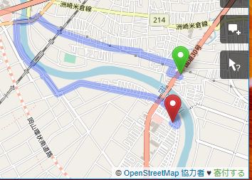
国道30号の笹ヶ瀬川を挟む区間の経路検索を、ORSMを用いて自転車モードで行った結果です。県道岡山児島線への大回りを強いられています。
Licensing
| Contains map data © OpenStreetMap contributors, made available under the terms of the Open Database License (ODbL).
The ODbL does not require any particular license for maps produced from ODbL data, produced maps may be subject also to other licences. |
File history
Click on a date/time to view the file as it appeared at that time.
| Date/Time | Thumbnail | Dimensions | User | Comment | |
|---|---|---|---|---|---|
| current | 13:04, 9 March 2019 | | 354 × 253 (33 KB) | Yumean1119 (talk | contribs) | 国道30号の笹ヶ瀬川を挟む区間の経路検索を、ORSMを用いて自転車モードで行った結果です。県道岡山児島線への大回りを強いられています。 |
You cannot overwrite this file.
File usage
The following page uses this file: