File:Osm-transport-map-prototype.png
Jump to navigation
Jump to search

No higher resolution available.
Osm-transport-map-prototype.png (380 × 378 pixels, file size: 93 KB, MIME type: image/png)
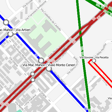
Early prototype of an OSM public transport map
Licensing
![]()
![]()
![]()
This screenshot contains OpenStreetMap Carto rendering.
The OpenStreetMap Carto map style is made available under the Creative Commons CC-0 1.0 Universal Public Domain Dedication.
- Attribution to the map data:
![]()
Contains map data © OpenStreetMap contributors, made available under the terms of the Creative Commons Attribution-ShareAlike 2.0 (CC-BY-SA-2.0).
File history
Click on a date/time to view the file as it appeared at that time.
| Date/Time | Thumbnail | Dimensions | User | Comment | |
|---|---|---|---|---|---|
| current | 17:41, 19 April 2011 | | 380 × 378 (93 KB) | Stanton (talk | contribs) | Updated to reflect new developments - correctly this time |
| 17:39, 19 April 2011 |  | 380 × 378 (93 KB) | Stanton (talk | contribs) | Updated to reflect new developments | |
| 00:16, 19 January 2011 |  | 377 × 378 (107 KB) | Stanton (talk | contribs) | fixed image size (previous image was too big) | |
| 00:06, 19 January 2011 |  | 503 × 502 (160 KB) | Stanton (talk | contribs) | Updated prototype: map background partially colored, reduced POIs, color scheme shown | |
| 18:13, 13 January 2011 |  | 377 × 378 (50 KB) | Stanton (talk | contribs) | Early prototype of an OSM public transport map |
You cannot overwrite this file.
File usage
The following page uses this file: