File:Osm gps-data-sources-comparison 1440.jpg
Jump to navigation
Jump to search


Size of this preview: 337 × 599 pixels. Other resolutions: 135 × 240 pixels | 270 × 480 pixels | 432 × 768 pixels | 576 × 1,024 pixels | 1,440 × 2,560 pixels.
Original file (1,440 × 2,560 pixels, file size: 678 KB, MIME type: image/jpeg)
Summary
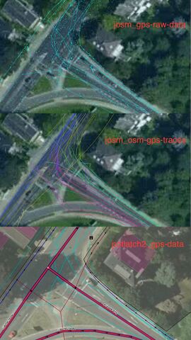
gps data sources comparison: API gps-raw-data vs osm-gps-traces (tms) vs potlatch2 Data from 2020-06-20 Location: https://www.openstreetmap.org/#map=19/50.75839/6.06354
Licensing
![]()
This file has been released into the public domain by the copyright holder, its copyright has expired, or it is ineligible for copyright. This applies worldwide.
Please, please use more specific template such as {{PD-self}} / {{PD-creator}} / {{PD-shape}} / {{PD-USGov}} / {{PD-old}} / {{PD-RU-exempt}} ... This template is not making clear why this work is in the public domain.
Please, please use more specific template such as {{PD-self}} / {{PD-creator}} / {{PD-shape}} / {{PD-USGov}} / {{PD-old}} / {{PD-RU-exempt}} ... This template is not making clear why this work is in the public domain.
File history
Click on a date/time to view the file as it appeared at that time.
| Date/Time | Thumbnail | Dimensions | User | Comment | |
|---|---|---|---|---|---|
| current | 17:19, 21 June 2020 | | 1,440 × 2,560 (678 KB) | Geow (talk | contribs) | gps data sources comparison: API gps-raw-data vs osm-gps-traces (tms) vs potlatch2 Data from 2020-06-20 Location: https://www.openstreetmap.org/#map=19/50.75839/6.06354 |
You cannot overwrite this file.
File usage
There are no pages that use this file.