File:Osmph-structures-noah.jpg
Jump to navigation
Jump to search

Size of this preview: 800 × 368 pixels. Other resolutions: 320 × 147 pixels | 884 × 407 pixels.
Original file (884 × 407 pixels, file size: 139 KB, MIME type: image/jpeg)
Summary
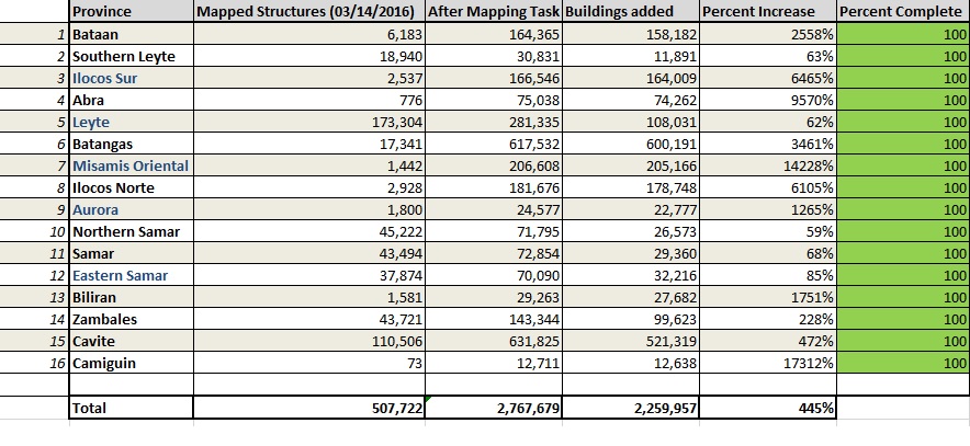
Table shows the 16 provinces mapped through the Project NOAH initiative in the Philippines. Adding up over 2.2 million structures in OpenStreetMap or an increase of 445%. Generated through Spatial Query in QGIS using OSM admin boundaries through OSM extracts provided by Geofabrik in various dates.
Licensing

The copyright holder of this file allows anyone to use it for any purpose, provided that the copyright holder is properly attributed. Redistribution, derivative work, commercial use, and all other use is permitted.
If you are the uploader, please provide proper attribution including source and name of author.
If you are the uploader, please provide proper attribution including source and name of author.
File history
Click on a date/time to view the file as it appeared at that time.
| Date/Time | Thumbnail | Dimensions | User | Comment | |
|---|---|---|---|---|---|
| current | 09:41, 28 February 2017 | | 884 × 407 (139 KB) | Schadow1 (talk | contribs) | Table shows the 16 provinces mapped through the Project NOAH initiative in the Philippines. Adding up over 2.2 million structures in OpenStreetMap or an increase of 445%. Generated through Spatial Query in QGIS using OSM admin boundaries through OSM ex... |
You cannot overwrite this file.
File usage
The following page uses this file: