File:PGardens.png
Jump to navigation
Jump to search


No higher resolution available.
PGardens.png (386 × 377 pixels, file size: 73 KB, MIME type: image/png)
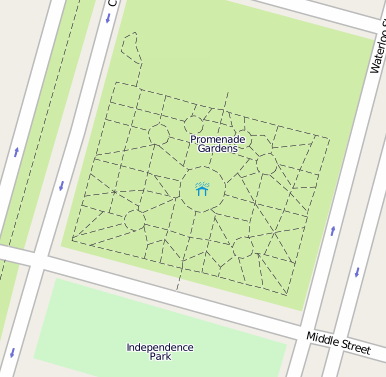
Paths between the flower beds and trees in the Promenade Gardens of Georgetown Guyana.
http://www.openstreetmap.org/?lat=6.816674&lon=-58.161338&zoom=18&layers=B000FTF
This is a Featured image, which means that it has been identified as one of the best examples of OpenStreetMap mapping, or that it provides a useful illustration of the OpenStreetMap project. If you know another image of similar quality, you can nominate it on Featured image proposals.
Front-page image for week 15 of 2010 (12–18 Apr.).
- Image descriptions
- Deutsch : Die Promenade Gardens in Georgetown, Guyana. Wege zwischen Bäumen und Blumen im Park.
- English : Promenade Gardens in Georgetown, Guyana. The paths among the trees and flowers in the public garden.
- français : Promenade Gardens à Georgetown, Guyana. Chemins entre les arbres et les fleurs de ce jardin public.
- italiano : I giardini del passeggio a Georgetown, Guyana. I sentieri tra gli alberi ed i fiori del giardino pubblico.
- magyar : Promenade Gardens a guyanai Georgetownban. Az ösvények fák és virágok között húzódnak a nyilvános kertben.
- polski : Promenade Gardens w Georgetown w Guyanie. Ścieżki wiodą wśród kwiatów i drzew w tym miejskim ogrodzie.
- português : Jardins Promenade em Georgetown, Guiana. Na imagem, os caminhos existentes entre árvores e flores no jardim público.
- русский : Сад Променад в Джорджтауне, столице Гайаны. Дорожки среди деревьев и цветов в городском парке.
File history
Click on a date/time to view the file as it appeared at that time.
| Date/Time | Thumbnail | Dimensions | User | Comment | |
|---|---|---|---|---|---|
| current | 15:34, 31 March 2010 | | 386 × 377 (73 KB) | Donaciano (talk | contribs) | Paths between the flower beds and trees in the Promenade Gardens of Georgetown Guyana. |
You cannot overwrite this file.