File:Parque Avenida Building in Paulista Avenue.jpg
Jump to navigation
Jump to search

Size of this preview: 281 × 598 pixels. Other resolutions: 112 × 240 pixels | 225 × 480 pixels | 361 × 768 pixels | 481 × 1,024 pixels | 962 × 2,048 pixels | 3,599 × 7,660 pixels.
Original file (3,599 × 7,660 pixels, file size: 12.43 MB, MIME type: image/jpeg)
This file and its description are from Wikimedia Commons.
Summary
| Description |
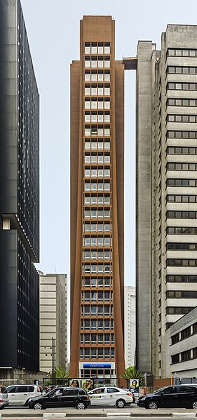
English: Parque Avenida Building in Paulista Avenue. Av. Paulista, 1776 - Bela Vista
São Paulo - SP 01311-920, Brazil. 23-story building, based on a metal frame covered gypsum. The first tower built by Aflalo & Gasperini office in 1965, It was the first building to present the language of the structural network through a horizontal and vertical frame on its facade. With reddish and different color, alleging a little larger than the top[1]
Español: Edificio Parque Avenida en la Avenida Paulista, 1776 - Bela Vista, São Paulo - SP 01311-920, Brasil. Edificio de 23 pisos, en base a un armazón de metálico forrado de yeso. la primera torre construida por la oficina Aflalo y Gasperini en 1965, fue el primer edificio para presentar el lenguaje de la red estructural a través de un marco horizontal y vertical en su fachada. Con el color rojizo y diferente, la base es un poco más grande que su parte superior[1]
Français : L'Immeuble Parque Avenida sur l'avenue Paulista à São Paulo au Brésil.[1]
|
| Date | |
| Source | Own work |
| Author | Wilfredor |
| Object location | | View this and other nearby images on: OpenStreetMap |
|---|

|
NOTE: This image is a panorama consisting of 5 frames that were merged or stitched in software. As a result, this image necessarily underwent some form of digital manipulation. These manipulations may include blending, blurring, cloning, and colour and perspective adjustments. As a result of these adjustments, the image content may be slightly different from reality at the points where multiple images were combined. This manipulation is often required due to lens, perspective, and parallax distortions.
|
|
This image was selected as picture of the day on Wikimedia Commons for 31 May 2015. It was captioned as follows: Other languages:
|

|
This image has been assessed under the valued image criteria and is considered the most valued image on Commons within the scope: Edifício Parque Avenida (facade). You can see its nomination here. |
Licensing
I, the copyright holder of this work, hereby publish it under the following license:
| This file is made available under the Creative Commons CC0 1.0 Universal Public Domain Dedication. | |
| The person who associated a work with this deed has dedicated the work to the public domain by waiving all of their rights to the work worldwide under copyright law, including all related and neighboring rights, to the extent allowed by law. You can copy, modify, distribute and perform the work, even for commercial purposes, all without asking permission.
|
References
| Annotations | This image is annotated: View the annotations at Commons |
File history
Click on a date/time to view the file as it appeared at that time.
| Date/Time | Thumbnail | Dimensions | User | Comment | |
|---|---|---|---|---|---|
| current | 00:47, 6 December 2014 | | 3,599 × 7,660 (12.43 MB) | wikimediacommons>Wilfredor | Rebuild from RAW |
File usage
The following 6 pages use this file: