File:Plano Turismo Frías.jpg
Jump to navigation
Jump to search

Size of this preview: 675 × 600 pixels. Other resolutions: 270 × 240 pixels | 540 × 480 pixels | 864 × 768 pixels | 1,175 × 1,044 pixels.
Original file (1,175 × 1,044 pixels, file size: 1.61 MB, MIME type: image/jpeg)
Summary
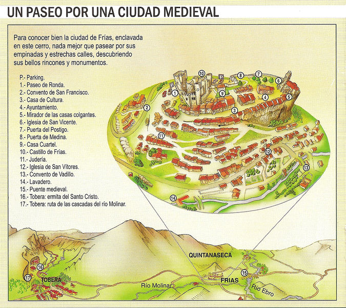
Plano con los Puntos de Interés de Frías, cedido desde la Oficina de Turismo del Ayuntamiento de Frías.
Licensing
![]()
This file has been released into the public domain by the copyright holder, its copyright has expired, or it is ineligible for copyright. This applies worldwide.
Please, please use more specific template such as {{PD-self}} / {{PD-creator}} / {{PD-shape}} / {{PD-USGov}} / {{PD-old}} / {{PD-RU-exempt}} ... This template is not making clear why this work is in the public domain.
Please, please use more specific template such as {{PD-self}} / {{PD-creator}} / {{PD-shape}} / {{PD-USGov}} / {{PD-old}} / {{PD-RU-exempt}} ... This template is not making clear why this work is in the public domain.
File history
Click on a date/time to view the file as it appeared at that time.
| Date/Time | Thumbnail | Dimensions | User | Comment | |
|---|---|---|---|---|---|
| current | 15:28, 19 April 2012 | | 1,175 × 1,044 (1.61 MB) | Cronoser wiki (talk | contribs) | Plano con los Puntos de Interés de Frías, cedido desde la Oficina de Turismo del Ayuntamiento de Frías. |
You cannot overwrite this file.
File usage
There are no pages that use this file.