File:Post box jitter.png
Original file (927 × 539 pixels, file size: 21 KB, MIME type: image/png)
Summary
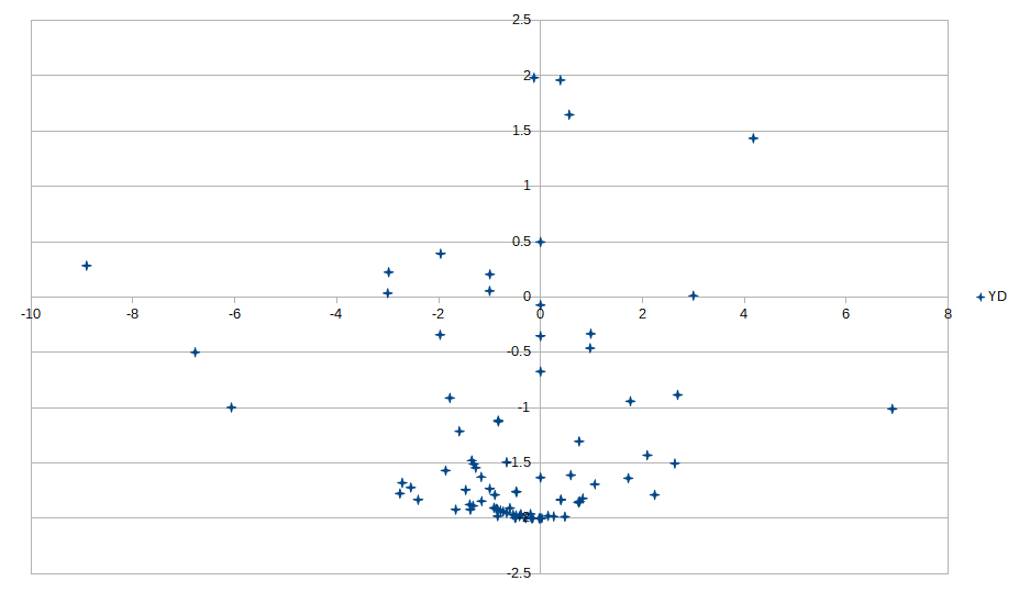
A selection of post boxes mapped on OSM were assigned putative UPRNs (unique identifiers of addressable objects created & maintained by Geoplace, and available as OpenData - without indication of object type or status). The UPRN data has associated lat/lon data. Position on OSM was compared with the UPRN location in the British National Grid projection (EPSG:27700). The plot shows the difference between locations in metres and azimuth.
Licensing
| Contains map data © OpenStreetMap contributors, made available under the terms of the Open Database License (ODbL).
The ODbL does not require any particular license for maps produced from ODbL data, produced maps may be subject also to other licences. |
File history
Click on a date/time to view the file as it appeared at that time.
| Date/Time | Thumbnail | Dimensions | User | Comment | |
|---|---|---|---|---|---|
| current | 20:36, 17 September 2020 | | 927 × 539 (21 KB) | SK53 (talk | contribs) | A selection of post boxes mapped on OSM were assigned putative UPRNs (unique identifiers of addressable objects created & maintained by Geoplace, and available as OpenData - without indication of object type or status). The UPRN data has associated lat/lon data. Position on OSM was compared with the UPRN location in the British National Grid projection (EPSG:27700). The plot shows the difference between locations in metres and azimuth. |
You cannot overwrite this file.
File usage
The following page uses this file: