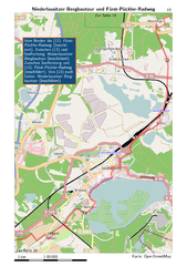
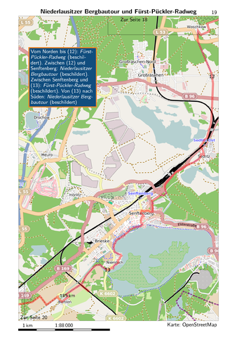
File:Radweg Berlin Dresden-Seite19.png
Jump to navigation
Jump to search


Size of this preview: 422 × 599 pixels. Other resolutions: 169 × 240 pixels | 338 × 480 pixels | 541 × 768 pixels | 722 × 1,024 pixels | 1,748 × 2,480 pixels.
Original file (1,748 × 2,480 pixels, file size: 1.53 MB, MIME type: image/png)
Summary
Page for printing with 300 dpi from A5 booklet Radweg Berlin Dresden (Author: Nils Larsen, Publisher: ADFC Sachsen). Contains data from OpenStreetMap, available under OdBL.
Extracted from PDF with Imagemagick:
convert -density 300 b-dd2014.pdf[18] -quality 85 Seite19.png
Licensing
![]()
![]()
![]()
This work is licensed under the Creative Commons Attribution-ShareAlike 2.0 License.
Attribution not specified as a parameter! THIS LICENSE ALWAYS REQUIRES ATTRIBUTION! Use {{CC-BY-SA-2.0|Attribution, typically name of author}} See Template:CC-BY-SA-2.0 for full description how this template should be used.
Note, there is
There is also
Attribution not specified as a parameter! THIS LICENSE ALWAYS REQUIRES ATTRIBUTION! Use {{CC-BY-SA-2.0|Attribution, typically name of author}} See Template:CC-BY-SA-2.0 for full description how this template should be used.
Note, there is
{{CC-BY-SA-2.0 OpenStreetMap}} for files based on old OSM map data, before the license change made on 2012-09-12.There is also
{{OSM Carto screenshot||old_license}} for files based on old OSM map data, before the license change made on 2012-09-12, created using OSM Carto map style.
| Contains map data © OpenStreetMap contributors, made available under the terms of the Open Database License (ODbL).
The ODbL does not require any particular license for maps produced from ODbL data, produced maps may be subject also to other licences. |
File history
Click on a date/time to view the file as it appeared at that time.
| Date/Time | Thumbnail | Dimensions | User | Comment | |
|---|---|---|---|---|---|
| current | 10:19, 19 April 2014 | | 1,748 × 2,480 (1.53 MB) | Radweg-berlin-dresden (talk | contribs) | Page for printing with 300 dpi from A5 booklet Radweg Berlin Dresden (Author: Nils Larsen, Publisher: ADFC Sachsen). Contains data from OpenStreetMap, available under OdBL. |
You cannot overwrite this file.
File usage
The following page uses this file: