File:Rail density map.png
Jump to navigation
Jump to search


Size of this preview: 800 × 370 pixels. Other resolutions: 320 × 148 pixels | 640 × 296 pixels | 1,350 × 625 pixels.
Original file (1,350 × 625 pixels, file size: 49 KB, MIME type: image/png)
This file and its description are from Wikimedia Commons.
Summary

|
File:Rail density map.svg is a vector version of this file. It should be used in place of this PNG file when not inferior.
File:Rail density map.png → File:Rail density map.svg
For more information, see Help:SVG. |
 |
| Description |
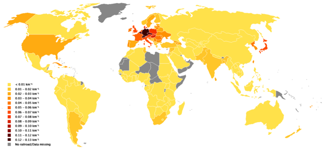
English: Blank world template from Wikimedia Commons, data from en:List of countries by rail transport network size and en:Countries_by_area
Compiled by en:User:GSchjetne
Deutsch: Dichte des Schienennetzes in km Schiene pro km² Fläche. |
| Date | 2 June 2006 (original upload date) |
| Source | Transferred from en.wikipedia to Commons by Tam0031 using CommonsHelper. |
| Author | GSchjetne at English Wikipedia |
Licensing
| This work has been released into the public domain by its author, GSchjetne. This applies worldwide. In some countries this may not be legally possible; if so: |
Original upload log
The original description page was here. All following user names refer to en.wikipedia.
- 2006-06-02 11:05 GSchjetne 1350×625×8 (21335 bytes) Blank world template from Wikimedia Commons, data from [[List of countries by rail transport network size]] and [[Countries_by_area]] Compiled by [[User:GSchjetne]]
File history
Click on a date/time to view the file as it appeared at that time.
| Date/Time | Thumbnail | Dimensions | User | Comment | |
|---|---|---|---|---|---|
| current | 12:12, 1 October 2018 | | 1,350 × 625 (49 KB) | wikimediacommons>A2D2 | Fixed Iraq and Uganda. |
File usage
The following 5 pages use this file: