File:Redbox1.JPG
Jump to navigation
Jump to search


Size of this preview: 450 × 600 pixels. Other resolutions: 180 × 240 pixels | 360 × 480 pixels | 576 × 768 pixels | 768 × 1,024 pixels | 1,920 × 2,560 pixels.
Original file (1,920 × 2,560 pixels, file size: 2.3 MB, MIME type: image/jpeg)
This file and its description are from Wikimedia Commons.
| Description |
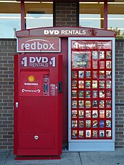
English: a RedBox video rental kiosk located on the east facing external wall of a Walgreens in Macomb, Illinois 61455 taken while facing west bound |
| Date | |
| Source | Own work |
| Author | IlliniGradResearch |
| Permission (Reusing this file) |
I, the copyright holder of this work, hereby publish it under the following license: This file is licensed under the Creative Commons Attribution-Share Alike 2.5 Generic license.
I, the copyright holder of this work, hereby publish it under the following license: This file is licensed under the Creative Commons Attribution-Share Alike 3.0 Unported license.
|
| Object location | | View this and other nearby images on: OpenStreetMap |
|---|
| Camera location | | View this and other nearby images on: OpenStreetMap |
|---|
File history
Click on a date/time to view the file as it appeared at that time.
| Date/Time | Thumbnail | Dimensions | User | Comment | |
|---|---|---|---|---|---|
| current | 06:00, 26 July 2010 | | 1,920 × 2,560 (2.3 MB) | wikimediacommons>Rotatebot | Bot: Rotate 90° |
File usage
The following page uses this file: