File:RelationsForConnectingE-Roads02.jpg
Jump to navigation
Jump to search
No higher resolution available.
RelationsForConnectingE-Roads02.jpg (432 × 353 pixels, file size: 14 KB, MIME type: image/jpeg)
This file and its description are from Wikimedia Commons.
Summary
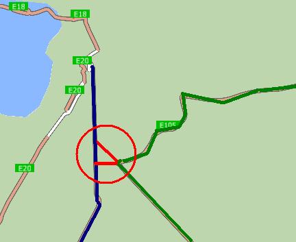
| Description |
Русский: Отношения для соединения маршрутов. Синяя линия - маршрут E 95, зелёная линия - маршрут E 105, красная линия - соединительное отношение. Карта для навигационной программы CityGuide сгенерирована для сайта http://peirce.gis-lab.info на основе данных OSM.
English: Relations for connecting routes. Blue line - route E 95, green line - route E 105, red line - connecting relation. The map for CityGuide software was made for website http://peirce.gis-lab.info, it is based on OSM data. |
| Date | |
| Source | OpenStreetMap and http://peirce.gis-lab.info |
| Author | contributors of OpenStreetMap and http://peirce.gis-lab.info |
| Camera location | | View this and other nearby images on: OpenStreetMap |
|---|
Licensing
| Description |
This map was created from OpenStreetMap project data, collected by the community. This map may be incomplete, and may contain errors. Don't rely solely on it for navigation. |
|||
| Date | (see file history) | |||
| Source | openstreetmap.org | |||
| Creator |
OpenStreetMap contributors |
|||
| Permission (Reusing this file) |
OpenStreetMap data is available under the Open Database License (details). Map tiles are licensed under the Creative Commons Attribution-ShareAlike 2.0 license (CC-BY-SA 2.0).
This file is licensed under the Creative Commons Attribution-Share Alike 2.0 Generic license.
|
|||
| Georeferencing | If inappropriate please set warp_status = skip to hide. |
File history
Click on a date/time to view the file as it appeared at that time.
| Date/Time | Thumbnail | Dimensions | User | Comment | |
|---|---|---|---|---|---|
| current | 20:24, 13 March 2013 | | 432 × 353 (14 KB) | wikimediacommons>Dinamik | == {{int:filedesc}} == {{Information |Description= {{ru|Отношения для соединения маршрутов. Синяя линия - маршрут E 95, зелёная линия - маршрут E 105, красная линия - сое... |
File usage
The following page uses this file: