File:RiceCrop04.png
Jump to navigation
Jump to search


Size of this preview: 800 × 401 pixels. Other resolutions: 320 × 161 pixels | 640 × 321 pixels | 1,024 × 514 pixels | 1,920 × 963 pixels.
Original file (1,920 × 963 pixels, file size: 2.49 MB, MIME type: image/png)
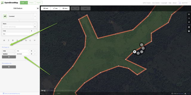
A zoomed in view of rice paddies in West Africa mapped in iD with proper tags.
https://www.openstreetmap.org/#map=17/7.69004/-9.1314
ISC
Screenshot of iD editor. It may contain different content with different licensing.
The iD editor software is published under ISC License – Copyright iD Contributors.
The iD editor software is published under ISC License – Copyright iD Contributors.
Permission to use, copy, modify, and/or distribute this software for any purpose with or without fee is hereby granted, provided that the above copyright notice and this permission notice appear in all copies.
THE SOFTWARE IS PROVIDED "AS IS" AND THE AUTHOR DISCLAIMS ALL WARRANTIES WITH REGARD TO THIS SOFTWARE INCLUDING ALL IMPLIED WARRANTIES OF MERCHANTABILITY AND FITNESS. IN NO EVENT SHALL THE AUTHOR BE LIABLE FOR ANY SPECIAL, DIRECT, INDIRECT, OR CONSEQUENTIAL DAMAGES OR ANY DAMAGES WHATSOEVER RESULTING FROM LOSS OF USE, DATA OR PROFITS, WHETHER IN AN ACTION OF CONTRACT, NEGLIGENCE OR OTHER TORTIOUS ACTION, ARISING OUT OF OR IN CONNECTION WITH THE USE OR PERFORMANCE OF THIS SOFTWARE.Only minor![]()
portions
Some minor portions of this image feature Bing aerial imagery.
Software screenshots and other illustrations of OpenStreetMap editing processes will often include some Bing imagery.
Bing imagery is not open licensed, but is generously made available to the OpenStreetMap project for deriving open licensed map data.
Such images in the OpenStreetMap wiki may be open licensed only where use of Bing is minor/incidental.
Bing imagery is not open licensed, but is generously made available to the OpenStreetMap project for deriving open licensed map data.
Such images in the OpenStreetMap wiki may be open licensed only where use of Bing is minor/incidental.
File history
Click on a date/time to view the file as it appeared at that time.
| Date/Time | Thumbnail | Dimensions | User | Comment | |
|---|---|---|---|---|---|
| current | 18:53, 14 November 2014 | | 1,920 × 963 (2.49 MB) | Bgirardot (talk | contribs) | A zoomed in view of rice paddies in West Africa mapped in iD with proper tags. https://www.openstreetmap.org/#map=17/7.69004/-9.1314 {{Bing image}} |
You cannot overwrite this file.
File usage
The following page uses this file: