File:Rottendorf-nach.png
Jump to navigation
Jump to search


Size of this preview: 580 × 599 pixels. Other resolutions: 232 × 240 pixels | 465 × 480 pixels | 851 × 879 pixels.
Original file (851 × 879 pixels, file size: 222 KB, MIME type: image/png)
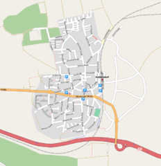
Rottendorf nach dem Mapping-Treffen am 27.04.2008 Mapnik-Export vom 23.05.2008
Licensing
![]()
![]()
![]()
This screenshot contains OpenStreetMap Carto rendering.
The OpenStreetMap Carto map style is made available under the Creative Commons CC-0 1.0 Universal Public Domain Dedication.
- Attribution to the map data:
![]()
Contains map data © OpenStreetMap contributors, made available under the terms of the Creative Commons Attribution-ShareAlike 2.0 (CC-BY-SA-2.0).
File history
Click on a date/time to view the file as it appeared at that time.
| Date/Time | Thumbnail | Dimensions | User | Comment | |
|---|---|---|---|---|---|
| current | 18:01, 23 May 2008 | | 851 × 879 (222 KB) | Uboot (talk | contribs) | Rottendorf nach dem Mapping-Treffen am 27.04.2008 Mapnik-Export vom 23.05.2008 |
You cannot overwrite this file.
File usage
The following page uses this file: