File:Rpn ref in Hoge Bergse Bos.JPG
Jump to navigation
Jump to search

No higher resolution available.
Rpn_ref_in_Hoge_Bergse_Bos.JPG (225 × 251 pixels, file size: 55 KB, MIME type: image/jpeg)
Summary
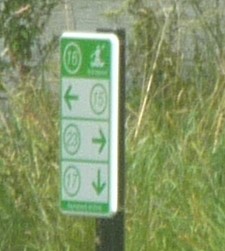
A node in a junction network for canoes. It can be tagged using the rpn_ref tag in Openstreetmap. Location: Hoge Bergse Bos, Bergschenhoek, Netherlands
Licensing
![]()
I, the creator of this work, hereby release it into the public domain. This applies worldwide.
In case this is not legally possible, I grant anyone the right to use this work for any purpose, without any conditions, unless such conditions are required by law.
Notice to creator or uploader: Please consider using {{CC0-self}} instead for your work.
"Releasing work to public domain" has some issues, as it is not well defined in some jurisdictions and/or it is not actually possible to "release to public domain". Using CC0 license achieves the intended effect while avoiding such problems and is well suited for media files.
File history
Click on a date/time to view the file as it appeared at that time.
| Date/Time | Thumbnail | Dimensions | User | Comment | |
|---|---|---|---|---|---|
| current | 19:38, 11 July 2018 | | 225 × 251 (55 KB) | A67-A67 (talk | contribs) | A node in a junction network for canoes. It can be tagged using the rpn_ref tag in Openstreetmap. Location: Hoge Bergse Bos, Bergschenhoek, Netherlands |
You cannot overwrite this file.
File usage
The following 4 pages use this file: