File:Tagging examples on a street view photo.jpg
Jump to navigation
Jump to search


Size of this preview: 800 × 302 pixels. Other resolutions: 320 × 121 pixels | 1,024 × 386 pixels.
Original file (1,024 × 386 pixels, file size: 329 KB, MIME type: image/jpeg)
Information
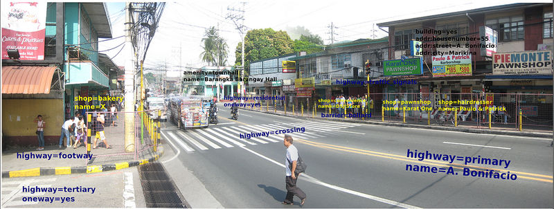
| Description | A street view panoramic photo showing tags that can be used to represent objects seen on the photo. The photo was taken in Barangka, Marikina looking west. |
|---|---|
| Author | maning |
| Source | http://www.flickr.com/photos/esambale/5810827865/ |
| Date | 2011-06-08 |
| Permission | CC-BY-SA 2.0 |
File history
Click on a date/time to view the file as it appeared at that time.
| Date/Time | Thumbnail | Dimensions | User | Comment | |
|---|---|---|---|---|---|
| current | 09:06, 17 July 2011 | 1,024 × 386 (329 KB) | Seav (talk | contribs) | ==Information== {{Information |Description = A street view panoramic photo showing tags that can be used to represent objects seen on the photo. |Source = http://www.flickr.com/photos/esambale/5810827865/ |Author = [[User:Maning|maning] |
You cannot overwrite this file.
File usage
The following page uses this file: